Fun waves today and tomorrow out of the wind
Southern Tasmanian Surf Forecast by Craig Brokensha (issued Wednesday October 5th)
Best Days: Today out of the wind, tomorrow morning out of the wind, Friday beginners, Sunday morning
Features of the Forecast (tl;dr)
- Easing mix of SW and S/SW swells tomorrow with strong NE winds
- Tiny Fri with fresh N/NE tending variable NW winds
- Small pulse of W/SW swell Sat PM with NW tending fresh SW winds, easing Sun with W/NW tending S/SE winds
- Small S/SW swell Tue PM and Wed with gusty N/NE-NE winds
Recap
Poor conditions and a building mix of windswell and stronger mid-period SW swell yesterday, cleaner this morning but easing back from the 2ft+ range. Winds are light and favourable for Clifton but will increase through the day from the E/NE (they've just come up).

Good sized sets this morning
This week and next (Oct 6 - 14)
Down, down, down. That's the outlook for the coming days so make the most of the current swell and work the strengthening E/NE winds this afternoon. We'll see the current swell dropping from 1-2ft tomorrow morning, slowed by a reinforcing pulse of S/SW energy generated by a weak front to the south of us yesterday.
Winds will remain strong and out of the NE tomorrow, favouring some breaks over others, with fresh N/NE tending NW winds on Friday but tiny leftovers, best for beginners.
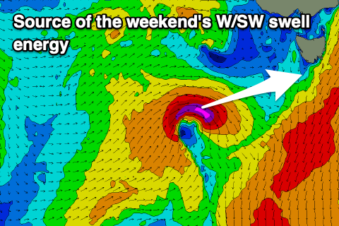
 Moving into the weekend and a small pulse of mid-period W/SW swell is expected across Clifton Saturday afternoon and Sunday morning, generated by a tight low and slim fetch of W/SW-SW gales being generated through our swell window.
Size wise it only looks to reach 2ft on the sets Saturday afternoon, easing from a similar size on Sunday along with deteriorating conditions. A trough will bring a SW change Saturday afternoon when the swell kicks, while Sunday should see morning W/NW winds and clean conditions ahead of S/SE sea breezes.
Longer term there's nothing major into early next week apart from a small, mid-period S/SW swell for later Tuesday but more so Wednesday. This will be generated by a weak polar front passing under us on Sunday/Monday, but we'll have a closer look at this Friday.

