Good swell spoilt by poor winds
Southern Tasmanian Surf Forecast by Craig Brokensha (issued Monday October 3rd)
Best Days: Wednesday and Thursday morning selected spots
Features of the Forecast (tl;dr)
- Moderate sized SW swell for tomorrow, peaking in the PM with strong SW tending S/SW winds
- Easing swell Wed with strengthening NE winds
- Small, easing S/SW swell Thu with strong NE-N/NE winds
Recap
Friday's swell eased back to a smaller but clean 1-1.5ft on Saturday, while a new SW groundswell kicked into the afternoon and held yesterday with great conditions and 2ft+ sets.
The swell has eased this morning with clean conditions again and 1-2ft leftovers.
This week and weekend (Oct 4 - 9)
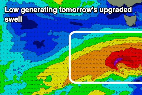
Looking at the coming two days, and we've got an upgrade in a SW swell due later tomorrow, easing Wednesday, with the polar low linked to it generating a fetch of W/SW gales to the south-west of us today.
The swell is now due to fill in and peak tomorrow afternoon with good 3ft sets across Clifton, easing back through Wednesday from 2ft+.
 Unfortunately a trough attached to the low will clip us tomorrow morning, bringing a strong S/SW change that might be SW at dawn.
This will create poor conditions across all locations, and come Wednesday, strengthening NE winds will create poor conditions across Clifton but open up options elsewhere.
Smaller surf is due on Thursday but still to 1-2ft owing to a trailing fetch of S/SW winds firing up south of us tomorrow, and winds will remain strong and out of the N/NE-NE.
Following this swell and funky winds, there's nothing significant on the cards as mid-latitude lows and troughs bring weather and swell from the western quadrant. This doesn't bode well for this coast but there should be plenty of options on the East Coast so check out Steve's notes when they're updated.

