Fun run of smaller swells and generally good winds
Southern Tasmanian Surf Forecast by Craig Brokensha (issued Friday September 30th)
Best Days: Saturday morning, Sunday morning, Monday morning, Wednesday morning, Thursday morning
Features of the Forecast (tl;dr)
- Easing surf Sat AM with N/NW tending S/SE winds
- New SW groundswell for Sat PM, peaking Sun with N/NW tending S/SW winds
- Smaller Mon with N/NW tending fresh S/SW winds
- Poor Tue with gusty S/SW winds
- Mix of new mid-period SW swell and S'ly swell Wed with NE winds
- Easing surf Thu with N/NE winds
Recap
Poor surf yesterday with strong onshore winds and an average swell.
This morning we've got a fun W/SW swell with better than expected conditions. The swell was a good 2-3ft with glassy conditions ahead of afternoon sea breezes.
This weekend and next week (Oct 1 - 7)
Looking at the weekend ahead and conditions will be clean again tomorrow morning with a light N/NW offshore and drop in size back to 1-2ft. Some new SW groundswell is due into the afternoon along with S/SE sea breezes, better as it peaks Sunday.
 This was generated by a tricky fetch of severe-gale NW winds tracking south-east towards the polar shelf through our swell window and we should see some good size from this source on Sunday morning with sets to 2ft+.
Winds look great and N/NW during the morning, tending variable ahead of a shallow S/SW change as a front clips us.
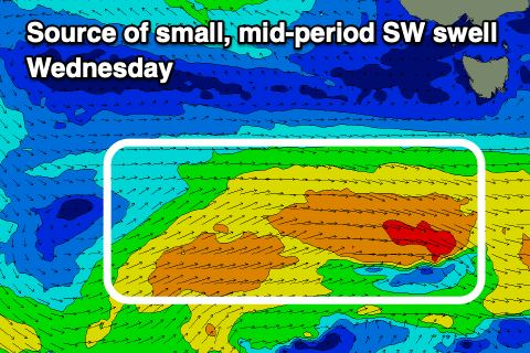
The back of this front will see a fetch of strong to sub-gale-force W/NW winds generated through our south-western swell window, producing a small, mid-period pulse of swell for Wednesday.
Ahead of this though, smaller 1-2ft waves are due across Clifton Monday and Tuesday with a N/NW offshore on the former, giving into a trough and S/SW change through the afternoon which will persist Tuesday as the trough pushes north.
 A high will move in quickly behind this trough, swinging winds to the NE along with a mix of the new mid-period SW swell to 2ft along with a S swell to 2ft+. The models are incorrectly combining these swells into Tuesday evening and Wednesday, over-forecasting the size.
The high pushing in mid-week will block our swell window resulting in a drop in size with N/NE winds into the end of the week, followed by tiny levels of W/SW swell next weekend. We'll have a closer look at this on Monday. Have a great weekend!

