Poor surf to end the week with average winds
Southern Tasmanian Surf Forecast by Craig Brokensha (issued Wednesday September 28th)
Best Days: Selected spots Friday PM, Saturday, Sunday morning, Monday morning
Features of the Forecast (tl;dr)
- Poor S/SE windswell tomorrow with background SW energy and strong S/SE winds, easing a touch into the PM and swinging SE
- Small W/SW swell building later tomorrow, peaking Fri AM with moderate E tending NE winds
- Easing surf Sat with N/NW tending E/NE winds
- New SW groundswell for Sat PM, peaking Sun with W/NW tending SE winds
- Easing swell Mon with N/NW tending SE winds
Recap
Monday afternoon's increase in inconsistent W/SW groundswell held into yesterday with variable winds and clean 1-2ft sets across Clifton. We saw a trough linked to the current strong onshore winds stalling at dawn, resulting in variable winds but small surf. It's since moved east bringing gusty onshore winds and choppy surf.
This week and next (Sep 29 – Oct 7)
The trough linked to today's strengthening onshore winds and deteriorating weather will become part of a broader, strengthening low that's currently sitting inland across NSW.
This low is due to move offshore and strengthen in the Tasman Sea, resulting in poor conditions under strong S/SE winds tomorrow, easing while tending more SE through the afternoon.
 Winds will then shift more E into Friday but this will continue to create average conditions across Clifton.
Swell wise a localised S/SE windswell will be most dominant tomorrow, while into the late afternoon and more so Friday a new mid-period W/SW swell is expected.
This swell was generated by a low to the south-west of Western Australia earlier this week and should produce 2ft sets Friday morning, easing into the afternoon but with those E winds, shifting more favourable and NE into the afternoon.
Cleaner conditions should be seen Saturday morning as winds swing to the N/NW but with fading 1-1.5ft sets.
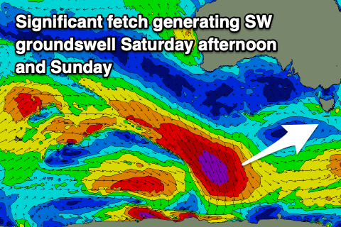
Into the afternoon we should see our new SW groundswell arriving, building to 1-2ft and peaking Sunday to 2ft+ across Clifton.
This is being generated by a slightly off-axis fetch of severe-gale NW winds pushing down towards the polar shelf today and tomorrow.
It's a tricky source but we should see some decent size with E/NE winds Saturday afternoon, W/NW Sunday morning ahead of S/SE sea breezes.
The swell should ease Monday from 2ft on the sets and with offshore winds ahead of sea breezes again.
Longer term we've got plenty more fun SW swell energy due into next week but winds look tricky as another deepening mid-latitude low moves in from the west. More on this Friday.

