Small swells with decent windows of clean conditions
Southern Tasmanian Surf Forecast by Craig Brokensha (issued Wednesday September 21st)
Best Days: Thursday, Friday morning, Sunday morning, Monday afternoon, Tuesday morning
Features of the Forecast (tl;dr)
- Small, inconsistent W/SW swell Thu and Fri with N tending S/SW winds Thu, variable tending strong S/SW early PM Fri
- Best pulse of inconsistent W/SW groundswell later Fri and Sat AM with strong S/SW tending S winds
- Small S/SE swell Sat, easing Sun with N/NW tending stronger E/NE winds
- Small, inconsistent W/SW groundswell Mon PM with strong N/NE winds, easing Tue with similar winds
Recap
Our inconsistent W/SW groundswell came in at a clean though straight 1-2ft yesterday, a touch smaller today and back to 1ft.
This week and weekend (Sep 22 - 25)
Looking at the coming days and we've got some slightly better and stronger pulses of W/SW groundswell due across the state from tomorrow (though inconsistent), peaking Saturday before easing into Sunday.
Unfortunately we'll see a trough spoil conditions into the weekend, but coming back to the sources, and a distant polar frontal progression saw fetches of gale to sub-gale-force W/SW to W/NW winds projected through our western swell window.
The first swell for tomorrow and Friday should come in around an inconsistent 2ft and with N'ly offshore tomorrow, shifting S/SW with a weak trough into the afternoon. Friday should see variable winds, light offshore in the morning ahead of a strong S/SW change early afternoon as a trough moves in.
 This will unfortunately spoil Saturday's swell which will come in at 2-3ft but with strong S/SW tending S winds and choppy conditions.
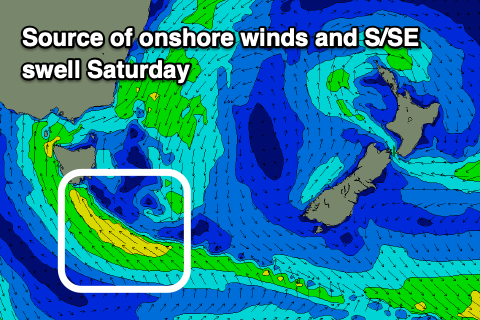
The trough is forecast to develop into a low to our south-east of us, generating a small S/SE swell for Saturday, easing Sunday as it weakens and drifts south-east. Easing 2ft+ sets are due and with N/NW winds ahead of stronger E/NE sea breezes.
Longer term, an inconsistent W/SW groundswell is due Monday afternoon and Tuesday morning but only to 1-2ft, generated again in our far swell window. Winds look to have a N/NE bias, strong at times but check back here Friday for more details.

