No surf until next week
Southern Tasmanian Surf Forecast by Craig Brokensha (issued Wednesday September 14th)
Best Days: Tuesday morning, later next week
Features of the Forecast (tl;dr)
- Small, inconsistent W/SW groundswell for later Mon, easing Tue with N/NW tending SE winds Mon and N tending strong E/NE winds Tue
- Moderate sized W/SW groundswell later next week
Recap
Solid surf yesterday morning with a reinforcing pulse of S/SW groundswell maintaining 3-5ft sets across the South Arm, but the easing trend was significant with 1-2ft waves left into this morning.
This week and next (Sep 15 - 23)
With the S'ly swell fading across the coast into today, there's nothing significant at all due over the coming days and into the weekend.
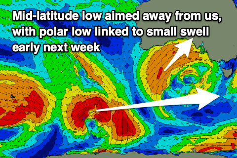
A strong, slow moving mid-latitude that's sitting south of Western Australia will expel all its energy too far north of our swell window.
 This means the South Arm will become tiny to flat tomorrow and remain this way until a small, inconsistent W/SW groundswell arrives later Monday and peaks overnight, easing Tuesday morning.
This swell only looks to reach 1-2ft max, generated by a strong but poorly structured low firing up south-west of Western Australia tomorrow, weakening while tracking south-east towards the polar shelf.
The swell should reach 1-2ft late afternoon Monday and ease from a similar size Tuesday with afternoon sea breezes on the former and N tending stronger E/NE winds on the latter.
Longer term there's a bit more Southern Ocean frontal activity due early next week through our western swell window, generating small to moderate levels of W/SW swell late week. We'll go over the sizes and local winds in more detail on Friday.

