Make the most of the current swell
Southern Tasmanian Surf Forecast by Craig Brokensha (issued Monday September 12th)
Best Days: Tomorrow morning, Wednesday
Features of the Forecast (tl;dr)
- Large, steadily easing S/SW groundswell tomorrow, much smaller Wed
- Moderate W-W/SW winds tomorrow AM, with S/SE sea breezes
- Mod-fresh N/NE winds Wed
- Tiny leftovers Thu with N/NE winds
- Inconsistent W/SW groundswell through next week
Recap
No real surf at all on the weekend until later yesterday when a strong polar low started pushing up and into us.
Today we've got a large W/SW groundswell with early variable winds which have quickly shifted strong onshore, favouring protected spots.
We should see the SW swell component of the swell now in the water across the South Arm.
This week and weekend (Sep 13 - 18)
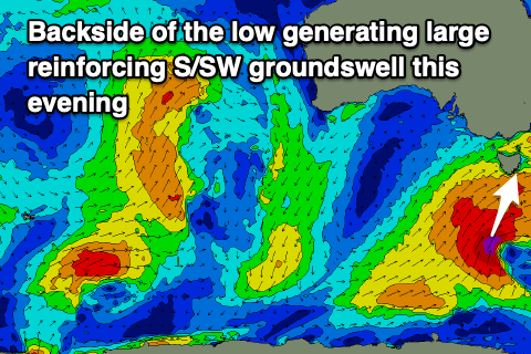
The slow moving polar low linked to the large W/SW tending SW groundswell today was still generating a great fetch of gale to severe-gale S/SW winds south of us last night. This will produce one final pulse of large S/SW groundswell for this evening, easing tomorrow from 4-6ft across Clifton.
 The swell is expected to ease steadily throughout the day and then down from 2-3ft on Wednesday.
Winds look to ease and improve rapidly through tomorrow, being moderate from the W-W/SW, tending variable ahead of S/SE sea breezes. So work the morning winds for the best waves.
Wednesday will be nice and clean with a moderate to fresh N/NE breeze.
Winds will strengthen and persist out of the N/NE through the end of the week as the swell bottoms out owing to a strong but slow moving mid-latitude low pushing in through the Bight, squeezing a strong blocking high out slowly to the east.
The low will be too far north to generate any decent swell for us unfortunately so we need to look beyond the weekend to next week for surf.
This period is looking more active with a progression of polar fronts expected to generate fun pulses of W/SW groundswell along with generally favourable conditions. More on this Wednesday though.

