Winds ruin the incoming swells
Southern Tasmanian Surf Forecast by Craig Brokensha (issued Wednesday September 7th)
Best Days: Wednesday next week
Features of the Forecast (tl;dr)
- Easing SE groundswell tomorrow with strengthening N/NE tending NE winds
- Tiny W/SW swell for Sun AM with strong W/NW tending SW winds
- Small-moderate sized SW swell Mon with strong S/SW tending S/SE winds
- Easing swell Tue with S/SE winds
- Smaller Wed but cleaner
Recap
Smaller surf but clean conditions yesterday with a mix of swells to 1-2ft, tiny this morning ahead of a fresh pulse of SE groundswell that should be hitting an inconsistent 2ft on the sets along with unfavourable NE winds.
This week and weekend (Sep 8 - 11)
Any increase in inconsistent SE groundswell seen this afternoon is set to ease tomorrow, dropping from an inconsistent 1-2ft on the sets across Clifton, bigger down the South Arm but with poor, strengthening N/NE tending NE winds.
We then look at the mid-latitude low drifting south-east and and across us Saturday and unfortunately only a very slim fetch of short-lived, local W/SW winds are forecast to be generated under the state, producing 1ft of W/SW swell for Sunday morning.
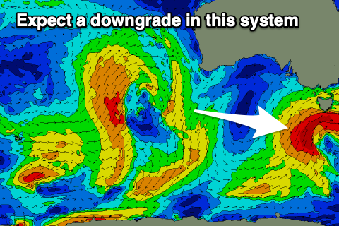
 Behind this low, a stronger polar low is due to project east-northeast towards us, but the models still diverge on the strength of this system.
The American version GFS and the least likely has the low being quite significant but the European solution is much weaker.
Therefore lower your expectations and expect a down grade in the size showing on the forecast charts.
In any case, the low will bring poor, onshore SW winds when it arrives Sunday, persisting from the S/SW tending S/SE on Monday at the peak of the swell.
So lower your expectations for this incoming swell.
Come Tuesday, winds will remain poor and from the S/SE as the swell eases, cleaner Wednesday but small.
Longer term there's still nothing major on the cards so check back Friday for an update on Monday's swell and local winds.

