Fun tomorrow with easing size
Southern Tasmanian Surf Forecast by Craig Brokensha (issued Monday September 5th)
Best Days: Tomorrow morning, Wednesday morning
Features of the Forecast (tl;dr)
- Easing S swell tomorrow with W/NW tending S/SE winds
- Inconsistent, smaller SE groundswell for Wed PM, easing Thu
- Moderate N tending gusty NE winds Wed, strong NE Thu
- Tiny Fri with strong NE tending N/NE winds
- Possible W/SW swell Sat with dicey winds
- Moderate sized SW swell building Sun with SW winds, easing Mon with S tending SE winds
Recap
Clean conditions Saturday morning with a drop in swell from Friday back to 1-2ft, while Sunday was a similar size but less consistent with early W winds.
Today the swell has kicked up out of the S’th but with average conditions.
This week and weekend (Sep 6 - 11)
The coming couple of days revolve mostly around the local wind and when conditions will clean up.
 We should see a high slowly edging further east tomorrow and this will bring more variable winds tomorrow morning, tending light W/NW through the morning along with easing levels of S’ly swell from today. 2-3ft sets should be seen in the morning, smaller later and then back to 2ft sets on Wednesday.
S/SE sea breezes are due from about lunch time tomorrow, and Wednesday should see moderate N tending gusty NE winds.
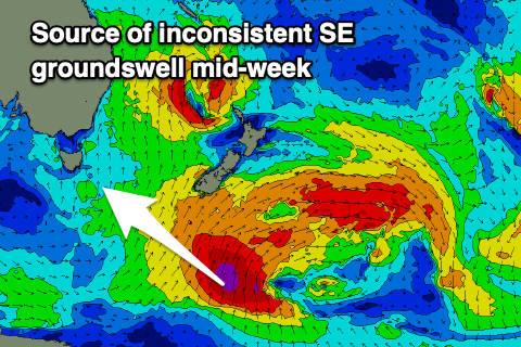
Into the afternoon on Wednesday a new pulse of SE groundswell is due, generated by a fetch of severe-gale to storm-force S/SE winds that developed south of New Zealand yesterday afternoon and evening on the backside of the strong polar frontal progression linked to today’s surf.
It’ll be inconsistent but sets to 2ft are due across Clifton into Wednesday afternoon, easing from 1-2ft on Thursday, with more size found down the arm.
Unfortunately Wednesday afternoon’s strengthening NE winds which will persist and become stronger Thursday will limit surfing options with this swell.
 On Friday we’ll see a NE-N/NE winds persisting as a mid-latitude low moves in from the west, bringing a strong change at some stage Saturday but the models are still divergent on the timing and it’s longevity.
Swell potential wise GFS is better than EC so keep your expectations low Saturday for any surfable swell. Also check back Wednesday for the latest on how this is shaping up.
A better polar low firing up behind the mid-latitude low should bring some better SW swell energy into the weekend and early next week but again with average winds from the SW-S as a high fills in behind the fronts. More on this Wednesday though.

