Surf options from late week
Southern Tasmanian Surf Forecast by Craig Brokensha (issued Monday June 20th)
Best Days: Friday afternoon, Saturday, Sunday morning
Features of the Forecast (tl;dr)
- Moderate sized mid-period W/SW swell building Fri PM with W/NW winds, holding Sat AM with N/NW winds
- Easing surf Sat PM, smaller Sun with NW tending SW winds
- New S/SW swell for Mon/Tue
Recap
We saw lingering, inconsistent levels of SE groundswell Saturday morning to 2ft on the sets, clean but tiny into yesterday morning ahead of strengthening NE winds.
Today we’ve got tiny peaky waves, only for the biggest of boards.
This week and weekend (Jun 21 - 26)
Following last week’s strong S and then SE groundswell, we’re in between action with no major swell or surf due in the South Arm until late week.
We’ll see winds swinging back to the north-west tomorrow evening as the first in a series of cold front pushes in from the west. The morning tomorrow will see N/NE breezes, easing and shifting N/NW ahead of the front but with no surf.
 NW tending N/NE winds are due on Wednesday, followed by stronger N winds on Thursday.
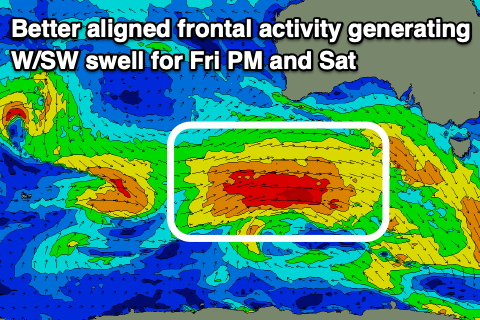
Moving into Friday, winds will shift to the W/NW and the frontal activity that’s been sitting too far north of our swell window will shift south and push under and across us Friday, Saturday and Sunday.
We’ll see a flurry of W’ly fetches generating mid-period W/SW swell that should build Friday afternoon, reaching 2ft to occasionally 3ft by dark, holding a similar size on Saturday morning. Wind look best on Saturday and N/NW, with Sunday seeing NW offshore winds ahead of a SW change early afternoon.
Following this some new mid-period S/SW swell may be seen early next week but we’ll have a closer look at this on Wednesday.

