Slow period ahead of large stormy surf
Southern Tasmanian Surf Forecast by Craig Brokensha (issued Friday June 3rd)
Best Days: Saturday morning, early Monday, later next week
Features of the Forecast (tl;dr)
- Fading S/SE swell tomorrow with NW tending variable winds
- Inconsistent W/SW groundswell for Mon through Wed with early N/NW winds Mon, shifting gusty SW mid-late AM
- W/SW-SW winds Tue-Wed
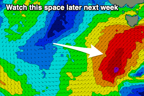
- Larger stormy surf later in the week
Recap
Strong levels of S/SE swell to 3ft+ across Clifton yesterday though easing back temporarily this morning though there should have been a little kick seen through the day.
This weekend and next week (Jun 4 - 10)
Any swell seen this afternoon will ease out of the S/SE tomorrow with clean conditions and fading 1-2ft sets under a NW tending variable winds.
Following this there's nothing too significant on the cards besides an inconsistent W/SW groundswell for Monday, with a secondary pulse for Wednesday.
These swells have been generated by a distant polar low firing up in our far swell window around and east of the Heard Island region, offering 1-2ft sets Monday through Wednesday.
 Conditions will be best on dawn Monday morning with a N/NW offshore ahead of a mid-morning SW change.
This will signal the start of a run of strong frontal systems pushing up and across the state under the influence of the Long Wave Trough, with the node moving slowly east before pushing across New Zealand next weekend.
This will see strong W/SW-SW winds through Tuesday and Wednesday with poorer S/SW winds into Thursday.
Size wise nothing major is due off the frontal activity early week but later Tuesday and Wednesday morning 3ft of S/SW swell is due with some larger S/SW swells due into the end of next week and weekend. More on this Monday. Have a great weekend!

