Fun surf later week
Southern Tasmanian Surf Forecast by Craig Brokensha (issued Monday May 30th)
Best Days: Thursday, Friday, Saturday morning
Features of the Forecast (tl;dr)
- Moderate sized S swell building Wed with strong S/SW-S winds
- Easing S swell Thu with a reinforcing S/SE swell with W/NW tending N/NW winds
- Reinforcing S/SE swell Fri with fresh N tending N/NE winds
- Fading SE swell Sat with gusty N/NE tending N/NW winds
Recap
A tiny bump of W/SW swell Saturday to 1-1.5ft, dropping Sunday from 1ft and maintaining this size today.
This week and weekend (May 28 – Jun 3)
The coming forecast period isn't too crash hot at all, as touched upon last week but there'll be fun surf later week.
We've got mid-latitude storms and no decent polar frontal activity, with a cold low that's currently moving in to our north-west due to be the main source of swell this week.
 Tomorrow will remain tiny but some new S'ly windswell is due to develop into Wednesday as the low moves across us, opening up the south of the state to a fetch of strong S'ly winds.
The low now looks weaker and size wise we'll only see 3ft of localised swell building Wednesday afternoon and with strong S/SW-SW winds.
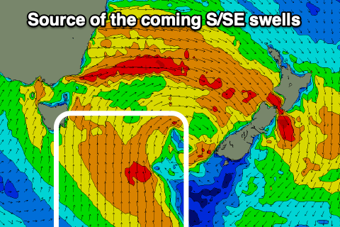
Winds are due to shift back to the W/NW on Thursday morning (N/NW afternoon) and we should see some fun S/SE swell in the mix from a broad fetch of S'ly winds developing south-east of us as the low broadens south of the Tasman Sea.
Sets to 3ft should continue across Clifton, easing slightly during the day, with a final pulse of S/SE swell Friday due to maintain 2-3ft surf.
Conditions will remain great with a N tending N/NE breeze which will favour some breaks over others.
Into the weekend the S/SE swell will fade quickly with easing 1-2ft sets and shifting N/NE to N/NW winds.
Longer term there's still nothing major on the cards for us until next week, but we'll take a closer look at this Wednesday.

