Fun S swell tomorrow
Southern Tasmanian Surf Forecast by Craig Brokensha (issued Wednesday January 19th)
Best Days: Thursday
Features of the Forecast (tl;dr)
- Mix of easing SW swell and building S'ly swell tomorrow with N/NE tending S/SE winds
- Easing S'ly swell Fri with N tending S/SE winds
- Tiny SW swell Sat with N tending S/SE winds
- Possible new swells next Thu/Fri
Large stormy swell out of the E developing next week but with onshore winds
Recap
A dawn window of clean conditions yesterday morning with slow 2ft sets across Clifton while today is poor with onshore winds in the wake of a trough.
This week and next (Jan 20 - 28)
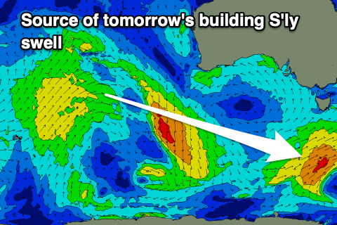
The current W/SW swell energy is due to drop back from a small 1-2ft tomorrow morning but a new pulse of mid-period S'ly swell will take its place, generated by a strengthening polar fetch that developed south of us yesterday.
 Strong to gale-force S/SW winds were generated in our swell window and the swell should arrive through the day, kicking to 2ft+ across the South Arm as it peaks into the afternoon, then easing from 1-1.5ft on Friday morning.
Conditions will clean up tomorrow with a light, morning N/NW breeze, ahead of S/SE sea breezes now, and then similar N tending S/SE winds on Friday.
The minimal pulse of SW swell for Saturday is still that, with the frontal progression linked to it being too poorly angled to generate any decent swell, aimed into the polar shelf.
1ft+ waves max are due and winds are now favourable for beginners in the morning and light offshore ahead of sea breezes.
Longer term there's nothing significant on the cards as a large, persistent blocking setup across the south of the country shifts south next week, blocking our major swell windows.
We should see a couple of polar fronts forming late in our swell window mid-late next week, generating some new swell for Thursday/Friday but we'll have a closer look Friday.

