New swell next week with average winds
Southern Tasmanian Surf Forecast by Craig Brokensha (issued Friday January 14th)
Best Days: Beginners tomorrow morning, Thursday morning for the keen
Features of the Forecast (tl;dr)
- Tiny SW swell tomorrow with N/NE tending S/SE winds
- New W'ly swell Tue with W/SW tending S/SW winds
- Easing W/SW swell Wed with S tending S/SE winds
- Tiny S/SW swell Thu, easing with strengthening NE winds
Recap
Tiny average surf the last two days and even a struggle for beginners.
This week and next (Jan 15 - 21)
 We may see a tiny pulse of swell tomorrow to 1ft, generated by an off-axis fetch of NW winds through our swell window this week.
Winds will be favourable for beginners with a N/NE offshore ahead of S/SE sea breezes.
There's then nothing significant on the cards until Tuesday's W'ly swell arrives from the strong mid-latitude low pushing in from the west.
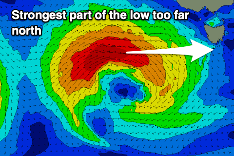
This low is now due to be a bit stronger but stay further north and out of our swell window, dipping east-southeast while weakening on Monday.
This now looks to limit the size to an inconsistent 2ft on Tuesday, easing from 1-2ft on Wednesday.
 Winds are still looking suspect as well and moderate from the W/SW on Tuesday, swinging more S/SW through the day, then lingering out of the S tending S/SE on Wednesday.
Thursday may see a small, reinforcing S/SW swell to 1-1.5ft with cleaner conditions under a NE breeze.
Longer term the outlook is a little unclear but we may see some new swell next weekend but with average winds. More on this Monday. Have a great weekend!

