Tricky winds with a couple of swells
Southern Tasmanian Surf Forecast by Craig Brokensha (issued Friday January 7th)
Best Days: Sunday (afternoon selected spots), Tuesday morning
Features of the Forecast (tl;dr)
- Strong S/SW winds with a building S'ly windswell tomorrow
- Easing S/SE windswell Sun with a building mid-period W/SW swell with light NE tending stronger E/NE winds
- Good W/SW swell Mon, easing through the day with moderate S'ly winds, freshening
- Easing W/SW swell Tue with light, variable S winds
Recap
Poor conditions with easterly winds yesterday, strengthening today and choppier.
This week and next (Jan 8 - 14)
A trough will bring a strong S/SW change and weak, building S'ly windswell through tomorrow, kicking to 2ft on the sets into the late afternoon/evening.
The trough will clear to the east Sunday allowing winds to ease and tend back to the NE through the morning before strengthening from the E/NE into the afternoon.
 We'll see a mix of easing S/SE windswell and small mid-period swell to 1-2ft.
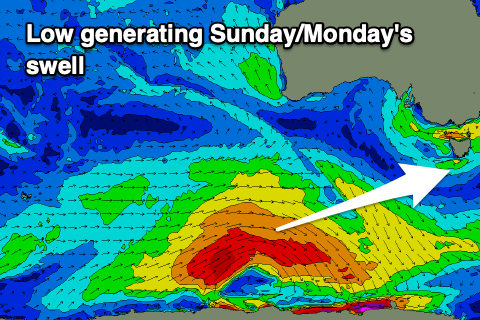
Our better W/SW swell into the afternoon is still on track, generated by a polar low that fired up south-west of Western Australia on Wednesday. We saw the best swell generating through yesterday though with a good fetch of strong to gale-force W/SW winds projected east towards us.
A kick to 2ft is due through Sunday afternoon with 2-3ft sets due on Monday morning when it peaks, easing through the day.
Winds will unfortunately swing back onshore with another trough pushing in from the west, bringing moderate S'ly winds, possibly more variable Tuesday morning with 1-2ft leftovers.
Longer term there's nothing major on the cards with weak frontal activity generating tiny pulses of background energy which will stop the South Arm going flat but will only be suitable for beginners. More on this Monday, have a great weekend!

