Small swells but mostly onshore
Southern Tasmanian Surf Forecast by Craig Brokensha (issued Wednesday January 5th)
Best Days: Sunday morning for the keen
Features of the Forecast (tl;dr)
- Tiny, fading W/SW swell tomorrow with strengthening E/NE winds
- Building S windswell Sat with strong S tending S/SE winds, easing Sun with NE tending stronger E/NE winds
- Building mid-period W/SW swell late Sun, peaking Mon with S winds
Recap
Tiny surf yesterday but clean and ideal for beginners, with a touch more energy due into today.
This week and next (Jan 6 - 14)
Any swell seen today is expected to fade through tomorrow and conditions will be choppy and bumpy with a gusty, strengthening E/NE breeze. 1-1.5ft sets may be seen, even smaller Friday with strong NE winds.
Moving into Saturday a trough will bring a S'ly change and kick up a weak S'ly windswell though it doesn't look to top 2ft, fading from 1-2ft Sunday.
 Winds will be strong from the S/SW on Saturday with Sunday seeing light NE offshore breezes, strengthening from the E/NE into the afternoon.
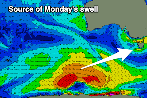
There should also be a new mid-period W/SW swell in the water, generated by a polar low that's developed south-west of Western Australia today.
This low is looking a touch better and we'll see a good fetch of strong to gale-force W/SW winds projected through our swell window tomorrow.
We should see the swell arriving Sunday afternoon but peaking Monday with sets to 2ft+ due across Clifton, easing through the afternoon.
Winds might spoil this swell though as another trough moves in from the west, creating poor conditions but we'll review this Friday.
Longer term, persistent polar fronts should produce tiny pulses of W/SW swell through the rest of next week with winds reverting back to the E/NE. Again with the average outlook it might be worth checking out the North East coast Forecaster Notes.

