Small to tiny period ahead
Southern Tasmanian Surf Forecast by Craig Brokensha (issued Friday December 31st)
Best Days: Tuesday, Wednesday and Thursday selected spots
Features of the Forecast (tl;dr)
- Tiny W'ly swell tomorrow with variable S winds, strengthening from the S/SE
- Tiny mid-period W/SW swell for Mon/Tue with W/SW tending S/SE winds on the former and variable tending fresh E/NE on the latter
- Slightly better W/SW swell for later Tue, peaking Wed with moderate NE tending strong E/NE winds, easing Thu with strong E/NE winds
Recap
Fun, clean 2ft waves yesterday and back to 1-1.5ft today with early variable winds.
This weekend and next week (Jan 1 - 6)
A front passing under us yesterday and into this morning should keep tiny 1ft+ waves hitting the coast tomorrow morning, easing through the day. Winds are a touch dicey and variable S'ly at dawn, increasing through the day so go the early if you're a beginner.
Sunday looks near flat while our first pulse of tiny W/SW swell for early next week is on track.
The source of this swell is a broad but relatively weak frontal progression pushing up and under Western Australia today, weakening tomorrow.
 Size wise the swell from this system looks minimal, coming in at 1-1.5ft through Monday and Tuesday.
Conditions unfortunately look lumpy and bumpy with onshore winds Sunday night only easing at dawn and tending W/SW and then S/SE into the afternoon.
Tuesday should see cleaner conditions under a variable wind, ideal for beginners.
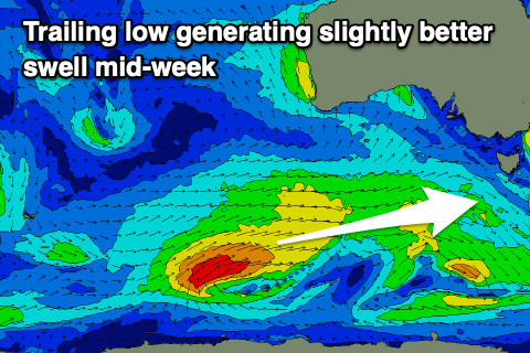
Into Tuesday afternoon a touch more energy is expected across the South Arm and more so Wednesday as a slightly stronger trailing low generates slightly stronger W/SW winds at a more southern latitude.
This should see 1-2ft sets developing across Clifton later Tuesday and into Wednesday, easing slowly Thursday from 1-1.5ft.
Winds on Tuesday afternoon look favourable for selected spots and gusty out of the E/NE, with moderate NE tending stronger E/NE winds on Wednesday. We may see stronger E/NE winds on Thursday as a surface trough deepens to our east but we'll review this Monday.
Longer term the trough may form into a low still, bringing a poor S'ly windswell next weekend, but more on this next update. Have a great New Year!

