Plenty of swell to work with but winds are a touch dicey
Southern Tasmanian Surf Forecast by Craig Brokensha (issued Wednesday December 22nd)
Best Days: Tomorrow morning, Friday morning, Saturday morning, Monday morning protected spots, Wednesday morning
Features of the Forecast (tl;dr)
- Easing moderate sized mix of swells tomorrow with W/NW tending S/SE winds, N tending strong E/NE Fri
- Inconsistent, small SE groundswell for later Fri, easing Sat. N/NW winds ahead of a SW change
- Mod sized SW swell for Sun, peaking in the PM with early W tending strong SW winds
- Easing mod sized S/SW swell Mon with W/SW tending S winds
- New SW swell for Wed with variable tending S/SE winds
Recap
Fun, clean 1-2ft waves across the Arm yesterday morning while today our stronger levels of mid-period and groundswell energy have filled in with good 3ft surf. Expect a bit more size this afternoon as the swell peaks but with bumpy conditions.
This week and weekend (Dec 23 - 26)
Today's building mix of mid-period W/SW swell and less consistent W/SW groundswell are due to peak into the afternoon, before easing back through tomorrow from a still solid 3ft to occasionally 4ft. The longevity of the swell is thanks to the constant progression of strong frontal activity through our swell window.
Friday will be much smaller and easing back from 1-2ft.
 Conditions over the coming days look favourable with a light, morning W/NW breeze tomorrow, shifting S/SE into the afternoon with N tending strong E/NE winds on Friday.
Into Friday afternoon and Saturday morning, an inconsistent SE groundswell is due, generated by a stationary fetch of SE gales south of New Zealand's South Island the last day or so.
It'll be inconsistent but sets to 1-2ft, bigger at more exposed spots down the South Arm.
With those E/NE winds into Friday afternoon it'll be tricky, while Saturday should see N/NW offshore winds ahead of a SW change.
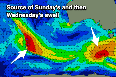
The front linked to this change will be part of a strengthening polar frontal progression with back to back fetches of gale to near gale-force W/SW winds expected to generate a moderate SW tending S/SW swell for Sunday and Monday.
The most size is due on the former with building surf to 3-4ft due across Clifton but with gusty W tending strong SW winds.
Monday should see weaker W/SW winds early (S'ly from mid-late morning) with easing surf from 3ft+.
By Tuesday the swell will be smaller and back to 1-2ft and winds still look a touch dicey.
Our reinforcing SW swell for Wednesday is on track, with a weak polar low following the frontal progression on the weekend, producing a fun spike of energy back to 2-3ft. We'll hopefully see more variable winds on Wednesday but we'll have a closer look at this Friday.

