Slow period continues with more action next week
Southern Tasmanian Surf Forecast by Craig Brokensha (issued Wednesday December 15th)
Best Days: Friday morning for beginners, Sunday and Monday for keen surfers
Features of the Forecast (tl;dr)
- Tiny, inconsistent W/SW groundswell building later tomorrow, peaking Fri with N/NW tending S/SE and then E/NE winds
- Slightly better, inconsistent W/SW groundswell for Sun with N/NW tending W/NW winds
- Reinforcing mid-period W/SW swell Mon with N/NW tending W/NW winds
- Larger swell likely mid-next week
Recap
Tiny surf but clean conditions each morning, suitable for learners.
This week and next (Dec 16 - 24)
 Tomorrow will remain tiny to flat but moving into the afternoon, a new, inconsistent W/SW groundswell will move in, generated in our far, far swell window south-east of South Africa.
This may offer 1ft sets later tomorrow but with sea breezes, with 1-1.5ft waves on Friday morning with a N/NW offshore ahead of S/SE sea breezes – possibly swinging E/NE later.
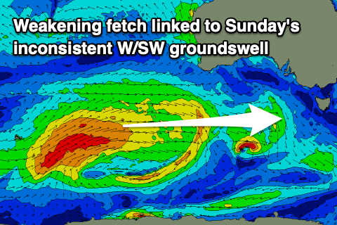
The swell will remain tiny Saturday ahead of our better, though still small to tiny W/SW groundswell on Sunday.
This swell was generated by a slightly stronger low forming around the Heard Island region earlier this week, with a great though distant fetch of gale to severe-gale W/SW winds projected towards us.
Infrequent 1-2ft sets should be seen on Sunday when it peaks and with N/NW offshore winds holding until a mid-afternoon W/NW change pushes through.
A weak mid-latitude front pushing in from the west through the weekend should produce some weaker, but more consistent mid-period W/SW swell for Monday coming in at 1-2ft.
 Winds look favourable all day again and stronger from the N/NW tending W/NW as a vigorous frontal progression pushes across us.
This will be ahead of a much more significant polar low developing south-west of Western Australia on the weekend, with it due to generate a moderate sized + W/SW groundswell for us mid-late week.
The models diverge a little on the exact size and intensity of this system so let's have another look at it on Friday.

