Tiny run of westerly swells ahead
Southern Tasmanian Surf Forecast by Craig Brokensha (issued Monday December 13th)
Best Days: No good days
Features of the Forecast (tl;dr)
- Tiny W swell building later tomorrow, easing Wed
- Tiny, inconsistent W/SW groundswell building late Thu, peaking Fri
- Slightly better, inconsistent W/SW groundswell for Sun with W/NW tending S/SE winds
Recap
Onshore winds and a bit of size on Saturday, cleaner across selected breaks yesterday with a reinforcing S/SW swell and surf to 2-3ft across Clifton.
This morning is smaller but more suited to beginners in selected spots out of the wind.
This week and weekend (Dec 14 - 19)
There's nothing significant on the cards for this coming forecast period with flukey W'ly swells or long-range energy with no size or consistency.
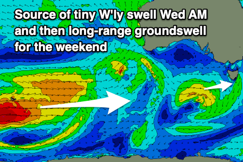
Tomorrow afternoon and Wednesday morning we may see 1ft of mid-period W'ly swell, generated by a stalling mid-latitude low that's currently south of the Bight. It's weak and dipping south-east and won't provide any major size.
 S/SE sea breezes will create poor conditions tomorrow afternoon with N/NE winds on Wednesday morning, creating clean conditions for beginners.
Following this into later Thursday and Friday a very inconsistent W/SW groundswell is due, generated by a strong polar low that formed south-east of South Africa, in our far, far swell window before pushing east and weakening south-west of Western Australia.
Again this doesn't look to top 1-1.5ft when it peaks Friday but conditions will be clean with a morning N'ly tending strong E/NE breeze.
Currently, there's a stronger polar low that's formed a little closer to us, in the Heard Island region and this looks to produce a touch more swell for the weekend. It'll be inconsistent but when it peaks on Sunday we should see 1-2ft sets with a W/NW tending S/SE breeze.
We may see a stronger frontal progression firing up and across us next week bringing a bit more swell activity, but more on this Wednesday.

