Poor week of onshore winds
Southern Tasmanian Surf Forecast by Craig Brokensha (issued Monday December 6th)
Best Days: Sunday morning, Monday for beginners
Features of the Forecast (tl;dr)
- Building SW swell late tomorrow, peaking Wed AM with SW tending S winds
- Inconsistent W/SW swell Thu with S/SW winds, easing Fri with S/SW tending S/SE winds
- New, moderate sized SW swell building late Fri, easing Sat with S/SE winds
- Easing surf Sun with NE winds
Recap
Poor, onshore surf on Saturday, much better yesterday with an offshore wind and clean, easing 2ft of SW swell.
Today there is still a 1-2ft wave on the coast with great, clean conditions again.
This week and weekend (Dec 7 - 12)
Tomorrow will start off tiny with a low point in swell but a small, poorly structured low firing up south of us during the day should produce some small, weak S/SW swell for Wednesday morning.
2ft sets are due across Clifton, easing through the day but winds will be onshore both tomorrow and Wednesday. Fresh SW'ly breezes are due tomorrow, shifting S/SW through the day with SW tending S winds persisting into Wednesday.
We'll unfortunately see onshore S/SW winds persisting through the end of the week as continued polar frontal activity skirts around the south-eastern side of a high to our west.
 This will bring swell but with the onshore breezes, there'll be limited options for a clean wave.
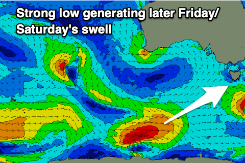
The strongest of these polar storms will be a strong low firing up under Western Australia tomorrow afternoon, generating a fetch of W/SW gales and good 3ft of swell for later Friday and Saturday morning.
Winds on Saturday will swing more S/SE as the high pushes under us, better out of the NE on Sunday morning but with smaller, fading 2ft surf.
Into early next week winds will shift more N/NE but the swell will bottom out. We'll have a closer look at this Wednesday though.

