Tricky winds to deal with this period
Southern Tasmanian Surf Forecast by Craig Brokensha (issued Monday November 29th)
Best Days: Dawn Saturday, Monday morning
Features of the Forecast (tl;dr)
- Building mix of W/SW swells Friday with fresh SW tending weaker SE winds
- Peak in W/SW groundswell Sat with dawn N/NW tending strong W/SW winds
- Mid-period SW swell Sun with strong SW winds
- Fading surf Mon with N tending E/NE winds
Recap
Fun surf yesterday with clean conditions and easing sets from an inconsistent 2ft, while today there's nothing left in the tank with tiny waves on the coast.
This week and next (Dec 2 - 10)
Tomorrow will remain tiny to flat in the arm, but on Friday we should see a new, inconsistent W/SW groundswell building and we've got an upgrade in an additional pulse of swell due later in the day and more so for Saturday.
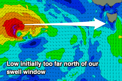
The source of these swells is effectively the same frontal progression, with an initial polar low developing in our far swell window on the weekend (east of Heard Island), then weakening as a secondary intense low fired up on the backside of it today, south of Western Australia.
 The initial polar low generated a great though distant fetch of W/SW-W gales and this should produce an inconsistent 1-2ft of swell for Clifton Friday afternoon and Saturday morning.
The secondary low firing up south of Western Australia today is looking stronger and will generate a more consistent but very westerly angled swell for later Friday and more so Saturday.
Today a fetch of W'ly gales are too far north of our swell window but the low will track east-southeast bringing the fetch more into our swell window. It'll still be very zonal (west to east) but we should see a fun spike in new swell late Friday to 2ft+, holding Saturday to a similar size.
Come Sunday the swell will be on the way out, fading from 2ft (mixed in with a new local SW swell).
 Local winds on Friday look average and SW tending SE. Saturday will be cleaner (though only for a short period) with a dawn N/NW breeze, shifting strong W/SW by 8am as another front passes under us. This looks to unfortunately leave strong SW winds in its wake while also bringing 2ft of mid-period swell from a short-lived trailing fetch.
Monday will be nice and clean but fading from 1-1.5ft.
Longer term some inconsistent, mid-period W/SW swell is on the cards for next week but winds are a little unsure with lots of trough activity developing. Therefore check back here Friday for the latest.

