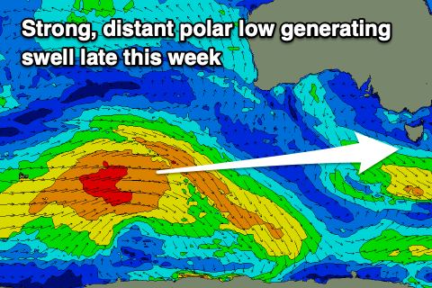
Small pulses of swell out of the west this period
Southern Tasmanian Surf Forecast by Craig Brokensha (issued Monday November 29th)
Best Days: Tomorrow, Wednesday morning beginners, Saturday morning, Sunday morning
Features of the Forecast (tl;dr)
- Easing W/SW swell tomorrow with N/NE tending strong E/NE winds, tiny Wed with N/NE tending NE winds ahead of a late change
- Building W/SW swell Fri PM with W/SW winds, holding Sat with W/NW tending W/SW winds, easing Sun with N/NW tending S/SE winds
- Fun W/SW swells next week
Recap
Clean conditions with small, fun surf on Saturday, tiny yesterday and only suited to beginners on big boards.
Today a new pulse of W/SW swell has lifted wave heights back to 1-2ft with clean conditions. There should be a bit more energy on offer this afternoon as the new W/SW swell continues to muscle up.
This week and weekend (Nov 30 – Dec 5)
Currently a good W/SW swell has filled in across the South Arm, generated by an elongated fetch of W/NW gales moving off-axis through our western swell window.
This frontal progression was a little faster than forecast Friday with the swell due to peak this afternoon, easing back through tomorrow from 2ft on the sets.
 Winds will be great for selected locations with a N/NE tending stronger E/NE breeze, N/NE tending variable NE ahead of a late trough/change Wednesday though tiny and easing from 1-1.5ft.
A low point in swell is due Thursday ahead of some new W/SW energy that will build Friday and peak Saturday.
The source of this swell is a strong polar low that's formed in our far swell window and is generating a fetch of weakening W/SW gales. The low will push slowly east today while continuing to weaken, leaving an inconsistent W/SW swell that should build Friday, then ease Saturday.
A small embedded front firing up on the tail of the weakening low looks to produce a reinforcing swell for Saturday, slowing the easing trend.
Size wise sets to 2ft are due Friday afternoon, holding Saturday, then easing Sunday. Winds look dicey and out of the W/SW on Friday, NW Saturday morning before shifting W/SW through the day. Sunday should be great with a N/NW offshore ahead of S/SE sea breezes as the swell fades.
Longer term there's plenty more polar frontal activity on the way generating fun surf through next week with initially unfavourable winds, improving later week, but we'll have a closer look at this Wednesday.

