Fun run of surf
Southern Tasmania Surf Forecast by Craig Brokensha (issued Friday 25th June)
Best Days: Tomorrow, Sunday morning protected spots, Monday, Tuesday
Features of the Forecast (tl;dr)
- Easing SW groundswell tomorrow, stopped by a reinforcing mid-period SW swell with W/NW tending NW and then N winds
- Mid-period W/SW swell building Sun with fresh W tending W/SW winds, peaking from the S/SW ealy Mon with N/NW tending NE winds
- Easing S/SW swell Tue with N winds
- S/SE groundswell Wed with fresh N/NE winds
Recap
A small, clean lift in S/SW swell yesterday for the patient while our better SW groundswell has filled in today with strong 3ft sets and a light SW breeze.
Today the swell is fun again, easing back from a clean, 2ft.
This weekend and next week (Jun 26 – July 2)
Today's SW groundswell will ease into tomorrow, but we'll see wave heights hold around 2ft+ through tomorrow as a reinforcing, mid-period SW swell fills in. This was generated by pre and post-frontal W/NW-W/SW winds through our swell window yesterday and conditions look great with a dawn W/NW breeze due to shift NW and then N into the afternoon.
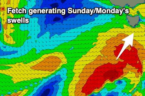
 Sunday will start a little slow but we'll see some mid-period W/SW energy building through the day as a strong polar front come small low pushes up and under us.
The surf from the mid-period energy only looks to build to 3ft or so by dark along with a morning W'ly breeze, shifting fresh W/SW into the afternoon.
Come Monday a stronger, S/SW groundswell is due to peak across the South Arm, easing through the day. This will be generated by a great fetch of W/SW gales attached to the polar storm moving under us Sunday, providing good 4ft sets across Clifton, easing into the afternoon back to 3ft and then down from 2ft Tuesday.
 Conditions look excellent with a N/NW tending variable NE breeze on Monday, N/NW tending N/NE on Tuesday.
On Wednesday a fun, reinforcing S/SE groundswell is expected from the backside of the polar low as it pushes onwards towards New Zealand. A great though short-lived fetch of severe-gale S/SE winds will produce the swell for Wednesday morning, coming in around 2ft to possibly 3ft, then easing with fresh N/NE winds.
Longer term there's nothing significant on the cards long term but there's the chance for a Tasman Low to form east of us next weekend, bringing an onshore, stormy increase in S'ly swell. More on this Monday. Have a great weekend!

