A couple more swells to come, then quiet
Southern Tasmania Surf Forecast by Craig Brokensha (issued Wednesday 17th March)
Best Days: Every day this period
Features of the Forecast (tl;dr)
- Easing S/SW swell tomorrow with fresh N tending E/NE winds
- New spike in SW groundswell Fri AM, easing Sat with a secondary smaller swell for Sat PM and Sun AM
- Morning N winds, fresher E/NE into the afternoons
Recap
A large kick in size through yesterday with variable morning winds and plenty of options, bumpy into the afternoon with sea breezes.
This morning the swell is on the way out with clean, easing 2-3ft sets across Clifton.
This week and next (Mar 18 - 26)
Yesterday's swell will continue to ease into tomorrow with clean, fun 1-2ft sets across Clifton with a fresh N tending E/NE breeze.
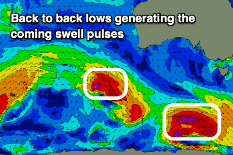
We then look at the spike in swell due Friday morning and the source of this will be a strong, deepening low that's currently tracking south-east from under Western Australia.
 This low will actually be classified as a 'bombing' low, dropping 24hPa within 24 hours, with a fetch of severe-gale to storm-force W/NW winds moving through our swell window today, with it gone by tomorrow.
The track, pace and alignment isn't ideal but the strength is significant and we should see sets pushing to 3ft across Clifton Friday morning, easing into the afternoon and smaller to 1-2ft Saturday morning.
Before the swell gets to ease further, a secondary pulse of SW swell will fill in, produced by a similar though slightly weaker low forming on the tail of today's.
Size wise, a fresh pulse back to 2ft is due later Saturday , easing Sunday with tiny surf due Monday
Coming back to Friday and winds will be similar to Thursday, moderate N tending fresh E/NE into the afternoon, with N/NW tending fresh E/NE winds on both Saturday and Sunday.
Longer term there's nothing major on the cards at all though continued weak frontal activity will likely stop the arm going completely flat. More on this in Friday's update.

