Fun swells on the way, then quiet
Southern Tasmania Surf Forecast by Craig Brokensha (issued Wednesday 10th March)
Best Days: Friday, Saturday morning, Sunday, possibly Tuesday morning
Features of the Forecast (tl;dr)
- New SW swell for Fri (peaking PM) with light N winds ahead of weak sea breezes, easing Sat with N/NW winds ahead of a strong S/SW change
- Windswelly swell Sun with NW tending W/NW winds
- Building SW groundswell later Mon, peaking Tue with W/SW tending S winds
Recap
A lift in swell yesterday with favourable winds in the morning, clean again today with sets hanging in at 2ft.
This week and next (Mar 11 - 19)
The current swell will become tiny into tomorrow, but into the end of the week, we've got our new SW groundswell due from a patchy polar low that's currently south-west of us.
This low is generating a broad fetch of strong W/NW winds, with stronger embedded gales. The swell is now due to fill in a bit earlier Friday, peaking to 2ft to possibly 3ft, easing back from 2ft Saturday morning.
 Winds look favourable and light N on Friday ahead of weak, if non-existent sea breezes, with N/NW winds ahead of a strong S/SW change through Saturday.
This change will be linked to a weak front moving through, with sets to 1-2ft due to persist Sunday under all day offshore NW tending W/NW winds as a stronger front edges in from the west.
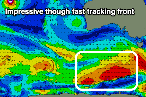
This stronger front will be fast moving, but provide some additional size and power to the mix Monday afternoon and more so Tuesday.
Size wise, we'll see the fetch of W/SW gales kicking the region up to 2ft Monday afternoon, further to 3ft on Tuesday.
Winds unfortunately look dicey and SW Monday afternoon in the wake of the front, lingering onshore into Tuesday, but we'll confirm this on Friday.
Following this swell the storm track will be unfavourable aligned and angled through our swell window, leading to a tiny run of surf, but more on this in Friday's update.

