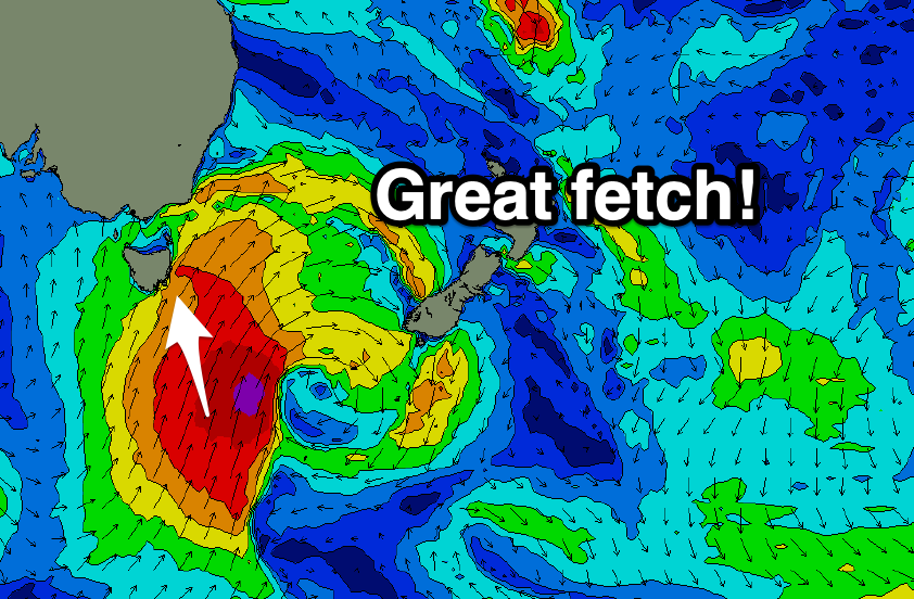
Large S'ly swell, easing from late tomorrow
Southern Tasmania Surf Forecast by Craig Brokensha (issued Friday 5th March February)
Best Days: Protected spots tomorrow, Sunday morning
Features of the Forecast (tl;dr)
- Large S'ly tending S/SE swell tomorrow, easing later and further Sun with strong SW tending S/SW winds tomorrow, N'ly ahead of S/SE sea breezes Sun
- New W/SW groundswell for Tue but with W/SW winds
Recap
Tiny surf yesterday morning but a new SW swell started to build with an onshore change into the afternoon, larger this morning and to a choppy 4-5ft. Even more swell should be pushing in this afternoon and protected spots are the only option.
This weekend and week (Mar 6 - 12)
The large swell that's currently breaking across the Arm is from a strong, elongated polar front projecting up and across us. This system is now pushing up into the Tasman Sea though a fetch of S/SW gales are still being generated in our southern swell window.
 This will keep the South Arm large through tomorrow with the swell coming more from the S tending S/SE angle, with sets to 4-6ft, easing later in the day, then easing from 3ft on Sunday morning.
Winds will remain best for protected spots tomorrow with a strong SW tending weaker S/SW breeze, great Sunday for Clifton with a N'ly offshore ahead of S/SE sea breezes.
Monday looks tiny but ideal for beginners, while a fun new W/SW groundswell is on the cards Tuesday.
The low linked to the swell is currently south-west of Western Australia, generating a healthy fetch of severe-gale W/SW winds north of our swell window, but will dip south-east today while maintaining its strength. It should weaken slowly tomorrow evening before pushing east and breaking down south-west of us Sunday.
The swell is due later Monday but should peak Tuesday morning to 2ft+ across Clifton. Winds look a touch dicey and W/SW, but we'll have to review this Monday. Beyond this swell there's nothing too major on the cards so make the most of the current energy. Have a great weekend!

