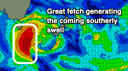
Large southerly swells to come
Southern Tasmania Surf Forecast by Craig Brokensha (issued Wednesday 3rd March February)
Best Days: Protected spots late tomorrow, Friday and Saturday, Sunday morning
Features of the Forecast (tl;dr)
- Strong new SW swell building Thu with W/NW tending strong SW winds, becoming large Fri, peaking in the PM with strong SW-S/SW winds
- Large out of the S'th Sat with strong S/SW winds, easing Sun with N tending S/SE winds
- New W/SW swell for Tue
Recap
A spike in windy, onshore swell yesterday, easing rapidly today and cleaner with sets to 1-2ft across Clifton.
This week and weekend (Mar 4 - 7)
We'll see the surf starting to build again through tomorrow ahead of a peak Friday, with an upgrade in the size.
The polar front linked to the swell will strengthen south-west of us and project north-east and north-northeast up into the Tasman Sea under the influence of the Long Wave Trough.
A strengthening fetch of strong to sub-gale-force SW winds will initially be generated tomorrow, strengthening to gale-force and swinging S/SW Friday while projecting north through our southern swell window.
 We'll see the surf starting to build through tomorrow from the SW, reaching 4ft+ by dark across Clifton, with Friday seeing the surf building further to 6ft through the afternoon.
Conditions will be clean tomorrow morning with a W/NW offshore, shifting strong late morning, and then strong SW-S/SW on Friday.
Saturday will still be solid out of the S/SE from the backside of the low with easing 4-6ft sets, down further from 3ft Sunday morning.
Conditions will remain best in protected spots with a strong S/SW breeze Saturday, light N'ly Sunday ahead of S/SE breezes.
Following the large southerly swell event we'll see a good W/SW groundswell for Tuesday next week from a low dropping south-east from the southern Indian Ocean, but more on this Friday.

