Tricky, large onshore weekend
Southern Tasmania Surf Forecast by Craig Brokensha (issued Friday 1st May)
Best Days: Saturday, Sunday, Monday morning, Tuesday beginners
Recap
Tiny waves yesterday, but today we've seen some new S'ly swell fill in across the Arm, originating from the tricky southern flank of a deep low that's developed south-west of us. Sets to 3ft were seen and this is a little ahead of schedule with more size likely through the day.
This weekend and week (May 2 - 8)
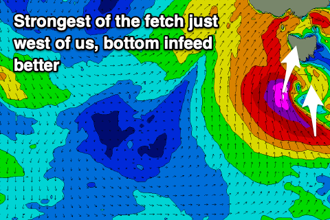
Currently the low sitting directly south-west of us is generating a fetch of S/SE gale to severe-gale winds in our southern swell window and this in itself will generate a moderate to large sized S'ly groundswell for tomorrow afternoon, but looking at the western flank of the low and unfortunately it looks to fall excruciatingly too west of our swell window.
 A fetch of severe-gale to near storm-force S tending S/SW winds projecting up and around the western flank of the low will be on the edge of our swell window and instead, reducing the size potential. We should still see some sizey swell spreading out from this fetch, mixed with short-range swell tomorrow afternoon as the low moves east, directing S/SW gales into us.
So there's a downgrade in the expected swell size for tomorrow, with Sunday morning likely to reveal the most size.
In the morning we're looking at 4-5ft surf, kicking through the afternoon to 4-6ft along with strong SW tending S/SW winds.
Come Sunday we're looking at similar strong but easing SW winds as the swell eases back from 5-6ft, with Monday still likely seeing 3ft sets, fading through the day and tiny Tuesday.
Winds will improve Monday and be lighter out of the W/NW, S'ly into the afternoon and then N tending SE on Tuesday.
The longer term outlook remains void of any major surf with a deepening but south-east tracking low mid-week the only thing to keep an eye on. More on this Monday. Have a great weekend!

