Tricky westerly swells on the way
Southern Tasmania Surf Forecast by Craig Brokensha (issued Monday 20th April)
Best Days: Tuesday, protected spots Wednesday, Thursday, Saturday through Monday
Recap
Saturday's large SW groundswell came in on forecast with good winds for protected spots, easing back rapidly Sunday with cleaner conditions across Clifton. Today there's nothing left in the tank with tiny clean leftovers.
This week and weekend (Apr 21 – 26)
Currently we've got a strong mid-latitude frontal system pushing across us, but the fetch it's generating is very west in nature and the progression as a whole is dipping south-east. This isn't ideal at all for swell generation but we may see 1-2ft sets across Clifton tomorrow, easing Wednesday.
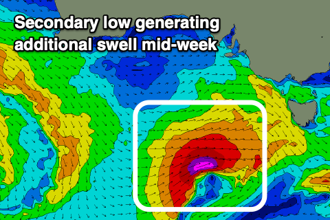
As the swell eases Wednesday though a secondary strong and tight mid-latitude low is forecast to move in, generating a fetch of gale to severe-gale W/SW winds while passing just under us.
 This slither of fetch will be better aligned in our swell window (just) and we should see a spike in W/SW swell through the afternoon Wednesday, kicking to 3ft+ across Clifton but then easing from 2ft to possibly 3ft Thursday morning.
Conditions tomorrow will be clean all day with a fresh N/NW offshore, W/NW tending strong W Wednesday with the low moving through. Thursday looks much cleaner again with a N/NW tending N offshore.
The surf will become tiny into Friday but moving into the weekend, we'll see a broad and elongated fetch of W'ly gales spreading out to our west, producing another W'ly groundswell event from Saturday through Monday that looks mostly to come in around 2ft. Conditions look favourable with winds persistent out of the N/NW.
Embedded stronger lows may generate spikes to 3ft at times through this period, but we'll look at this closer on Wednesday.
Longer term it looks like we'll see more W/SW swell from late next week, but we'll go over this again on Wednesday.

