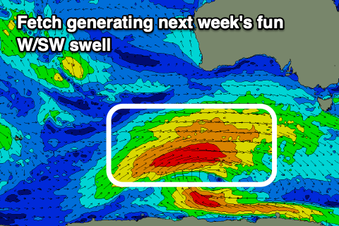
Fun W/SW swell for next week
Southern Tasmania Surf Forecast by Craig Brokensha (issued Wednesday 22nd January)
Best Days: Monday, Tuesday morning, Wednesday morning
Recap
Tiny onshore surf yesterday, cleaner today but still tiny.
This week and weekend (Jan 23 – 26)
A strong mid-latitude front-come low that's sitting in the Bight is generating plenty of wind and swell but it's too far north to generate any size for us.
Expect tiny 1ft waves through later tomorrow and Friday, if that.
 The better positioned and stalling polar low is expected to generate a good fetch of strong to gale-force W/SW winds initially in our medium-range swell window, pushing a touch closer but then a little too far north and not ideally within our swell window.
What we should see is a prolonged W/SW groundswell event, building from late Sunday and likely reaching 1-2ft by dark but coming in at a better 2ft or so Monday, persisting Tuesday, with the rare bigger set possible during these days.
The swell will then tend more W'ly resulting in a drop in size from 1-2ft on Wednesday.
Conditions look clean through this period with a N/NW tending E breeze Monday, N/NW most of Tuesday ahead of a S'ly change late afternoon and then N/NW winds Wednesday morning ahead of a late morning W/SW change.
Longer term we've got more W'ly swell on the cards late next week and into the weekend, but more on this Friday.

