Average outlook for the period
Southern Tasmania Surf Forecast by Craig Brokensha (issued Friday 20th September)
Best Days: Monday morning, Thursday morning
Recap
A strong SW groundswell with gusty N/NE winds, favouring more exposed locations but a bit under expectations and to an inconsistent 3-4ft off Clifton, smaller through the day and back to 1-2ft today.
Today’s Forecaster Notes are brought to you by Rip Curl
This weekend and next week (Sep 21 - 27)
I hope you made the most of yesterday as there's not much on the cards for us at all until next weekend.
Tomorrow will be tiny, and a new W/SW groundswell showing on the charts was generated too far north of us to generate any size. We'll be lucky to see 1-1.5ft waves later tomorrow, easing from a similar size Sunday with N/NE tending stronger N/NW winds tomorrow and W/NW tending W/SW winds Sunday.
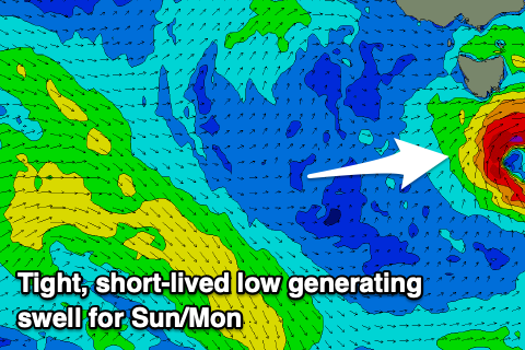
 A low forming south of us on Sunday looks to also generate a brief burst of SW winds in our swell window, producing a small pulse of swell to to 2ft+ into the afternoon but with that change.
Monday may see 1-2ft waves, easing through the day with NW tending W/SW winds.
Longer term a polar front strengthening south of us early next week should generate a weak but broad fetch of SW winds in our southern swell window, producing a 2ft+ of S/SW swell for later Wednesday and Thursday morning with onshore winds, possibly more variable Thursday morning.
Of greater importance is a stronger polar low due to form south-west of WA early next week, generating a W/SW groundswell for next weekend, but we'll have a closer look at this Monday. Have a great weekend!

