Strong swells and favourable winds
Southern Tasmania Surf Forecast by Craig Brokensha (issued Monday 16th September)
Best Days: Tuesday morning, Wednesday from mid-late morning, Thursday, early Friday
Recap
Onshore and small Saturday, tiny and clean Sunday morning ahead of a late increase in swell as winds held out. Today our bigger increase in swell was met with average conditions again and better days to come.
Today’s Forecaster Notes are brought to you by Rip Curl
This week and weekend (Sep 17 - 22)
Today's mix of swells will ease into tomorrow, with a reinforcing S/SW pulse from a fetch of SW gales under us today.
Clifton should ease back from a fun 3ft+ with a N/NW offshore, W/SW into the afternoon.
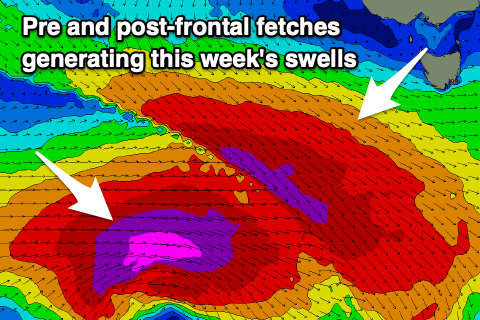
 We then move onto Wednesday and more importantly a deep and intense low that's formed south-west of WA.
This low is expected to drop to a central pressure of 929hPa and when squeezed against a high, some 100hPa higher sitting just south of Adelaide, we'll see a significant fetch of storm-force W'ly winds projected through our south-western swell window today and tomorrow. The low will then pass under us early Wednesday morning while weakening.
This will generate a large, long-period and significant SW groundswell that's due to arrive later Wednesday afternoon and peak overnight, easing steadily Thursday.
Ahead of this swell though, a small to moderate sized W/SW groundswell is expected to arrive through Wednesday morning, generated by a pre-frontal fetch of severe-gale NW winds, aimed at angles to our swell window.
This swell itself should kick later morning to 2-3ft across Clifton (tiny at dawn), with the SW groundswell kicking on dark to 4-5ft, peaking overnight and easing from 4-5ft Thursday morning. Larger sets will be seen overnight but the timing isn't ideal.
Winds will be great in the morning N/NW offshore and, shifting E-E/SE creating bumpy conditions into the afternoon.
Thursday will then see fresh and strengthen N/NE winds, holding Friday as the swell fades further from 1-2ft or so.
Longer term there isn't too much on the cards, with an inconsistent but west swell due to build Saturday and ease Sunday, generated too far north of our swell window.
We may see a weak trough form into a low just east of us on the weekend, producing a small weak S/SE swell, but the models aren't overly keen on this. So make the most of the coming days!

