Windy, improving weekend, better swells next week
Southern Tasmania Surf Forecast by Craig Brokensha (issued Friday 6th September)
Best Days: Sunday morning, later Tuesday, Wednesday and Thursday
Recap
Tiny waves for beginners and a log yesterday and today.
Today’s Forecaster Notes are brought to you by Rip Curl
This weekend and next week (Sep 7 - 13)
Tomorrow will be poor with strong onshore winds as a mid-latitude low moves across us. A new SW groundswell is due to build into the afternoon but with strong SE tending S/SE winds and terrible weather. There'll also be a S/SE windswell in the mix.
Winds should go more variable and light N/NW through Sunday morning with a small mix of easing SW and S/SE swells from the 2ft range on the sets.
 Monday looks poor as a strong front moves across us, bringing strong onshore SW tending S/SW winds though no significant increase in size. Localised fetches of S/SW winds will generate a weak and sloppy 2ft max of swell.
We've got better groundswells on the cards from late Tuesday and more so Wednesday/Thursday.
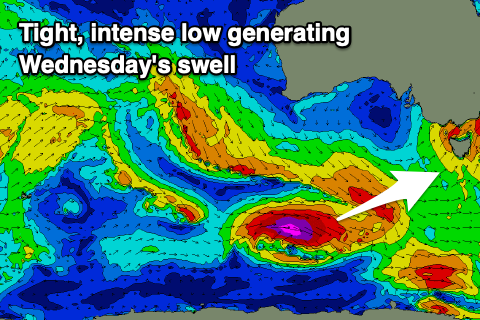
A tight and intense low is forecast to develop south-west of WA this weekend and generate a fetch of severe-gale to storm-force W'ly winds in our swell window while tracking east.
A moderate sized, long-period W/SW groundswell is due, arriving overnight Tuesday and peaking Wednesday to 3ft+ across Clifton.
Following this a secondary low may fire up on the tail of this initial low, producing an additional swell for Thursday, but the models diverge on this outcome, with EC having a weaker system.
We'll have to have a closer look at this on Monday though. Coming back to the local winds and Tuesday looks offshore most of the day with a W/NW-NW breeze and inconsistent W/SW groundswell into the afternoon to 2ft, N/NW-N all day Wednesday with the new swell. Have a great weekend!

