Slow week, more action from the weekend
Southern Tasmania Surf Forecast by Craig Brokensha (issued Monday 2nd September)
Best Days: Thursday morning for the desperate, Sunday morning
Recap
Great conditions with an easing S/SW swell from 2-3ft Saturday, tiny and ideal for beginners yesterday.
Today the surf was near flat and unsurfable.
Today’s Forecaster Notes are brought to you by Rip Curl
This week and weekend (Sep 3 - 8)
Tiny surf will pad out much of this week with no significant swell on the cards for the South Arm.
The storm track is too zonal and north of us, with a possible tiny hint of W/SW swell later Wednesday and Thursday morning from a front dipping east-southeast through our swell window. A fetch of strong to near gale-force W/NW winds will be generated, producing 1-1.5ft of swell at best.
 Winds on Wednesday will be offshore in the morning and out of the N/NW, but a shift to the W/SW is expected through the afternoon as the swell builds, best Thursday morning and with a NW'ly ahead of S/SE sea breezes.
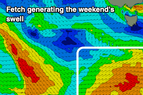
Later in the week a strong polar low will form south-west of us, but the pre-frontal fetch will be too NW, and the post-frontal fetch smaller in scope and fast moving.
We should still see some fun S/SW groundswell from this source, kicking later Saturday and peaking Sunday morning to 2ft+. Winds look onshore Saturday afternoon and better Sunday and out of the NW.
Following this we may see a series of stronger polar storms firing up and across us next week, but more on this Wednesday.

