Smaller swells to come this period
Southern Tasmania Surf Forecast by Craig Brokensha (issued Friday 23rd August)
Best Days: Sunday morning, Monday morning, Wednesday
Recap
Protected spots were the go yesterday with the south in the swell, cleaner and better across normal breaks this morning with easing 2-3ft sets.
Today was cleaner but back to a small 1-2ft out of the S'th.
Today’s Forecaster Notes are brought to you by Rip Curl
This weekend and next week (Aug 24 - 30)
The coming forecast period isn't too flash at all. We'll be looking at smaller swells until mid-late next week.
A front that was expected to generate a small pulse of swell for Sunday is now weaker and we'll be lucky to see much over 1-2ft across Clifton in the morning.
A slightly better swell is likely on Monday morning, generated by a weak polar frontal system moving through on the weekend.
 Again we're only looking at 1-2ft waves across Clifton Monday and possibly Tuesday morning.
Winds will be favourable though and from the W/NW Sunday morning, W/SW into the afternoon and NW tending W/NW on Monday.
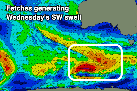
We'll see some better swell from Wednesday as a stronger polar frontal progression moves in from the west, generating pre-frontal W/NW strong to gale-force W/NW winds in our south-western swell window.
Some fun swell is due, possibly later Tuesday but more so Wednesday morning to 2ft+ with a gusty NW wind ahead of an afternoon W/SW change.
This change will be linked to a strengthening polar front/low moving across us and may generate a pulse of decent S/SW groundswell later week to the 3ft range as onshore winds swing back offshore. More on this Monday though. Have a great weekend!

