Building westerly swells, large late week
Southern Tasmania Surf Forecast by Craig Brokensha (issued Monday 22nd April)
Best Days: Wednesday afternoon, Thursday, protected spots Friday through Sunday
Recap
A good clean fun mix of swells on Saturday, clean though tiny and ideal for beginners yesterday and today.
Today’s Forecaster Notes are brought to you by Rip Curl
This week and weekend (Apr 23 - 28)
Any swell seen today from a tight though poorly aligned low over the weekend will fade tomorrow, with the coast due to become tiny to flat.
As touched on last update, the outlook from mid-late week is much more active as we see a series of strengthening fronts moving in from the west, with the first two being of moderate strength, while the third looks to be a doozy.
The first frontal system will strengthen on approach tomorrow, with a great fetch of W/SW gales forecast to be generated through our western swell window, reaching severe-gale while passing below us.
 This will generate a building W/SW groundswell Wednesday, peaking later to 2-3ft across Clifton, tiny early. Winds looks favourable all day and out of the N/NW, tending W/NW later afternoon.
A secondary zonal front moving in on Wednesday should generate a reinforcing W/SW swell for Thursday to 2-3ft under W/NW tending late NW winds as the strongest of the storms approaches.
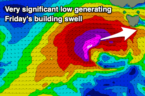
This third storm is very significant, with it strengthening south of WA, just south enough to be in our western swell window. A fetch of severe-gale to storm-force W/SW winds will be projected towards us, with the storm broadening in scope as it approaches us, moving across the state Friday morning.
As the storm moves across us we'll see a trailing fetch of severe-gale SW winds aimed in our south-western swell window.
What we can expect is a large long-period W/SW groundswell to build rapidly Friday, reaching 4-6ft across Clifton but with a lot of west in the direction. There'll be some SW component to the swell but likely only after dark Friday and fading Saturday.
A fourth frontal system moving in on Saturday should steady the easing trend through the weekend, dropping more noticeably from Sunday. Winds on Friday will be from strong W/NW, tending W/SW into the afternoon, similar Saturday and dicey from the W Sunday.
Longer term the surf will continue to ease into early next week with nothing too significant on the cards.

