Slowly easing S/SE-SE swell with poor conditions
Southern Tasmania Surf Forecast by Craig Brokensha (issued Friday 23rd November)
Best Days: Possibly protected spots early tomorrow, Monday morning
Recap
Onshore small to tiny surf yesterday, while today a stormy S/SE windswell is on the build but with poor winds.
Today’s Forecaster Notes are brought to you by Rip Curl
This weekend and next week (Nov 24 - 30)
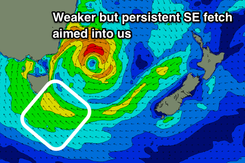
Currently we've got a deep and powerful Tasman Low sitting off our East Coast, but it's positioned a little further east than forecast on Wednesday, such is its dynamic nature.
This has resulted in larger than expected surf across the East Coast as the strongest winds are currently more in their swell window, compared to further west and into the South Arm.
 This will limit the size expected this afternoon and tomorrow morning as the low starts to slowly weaken.
Strong, but not gale-force S/SE-SE winds will persist through our swell window this evening and tomorrow before slowly abating.
Swell wise we're looking at surf to 4ft or so tomorrow morning on the sets, easing through the day and back from 2-3ft Sunday and 1-2ft Monday.
Winds will remain onshore though and from the S/SE tomorrow, but we'll likely see an early S/SW breeze favouring more protected spots.
Sunday will be poor with S/SE tending SE winds, while on Monday morning a light W/NW offshore is due early morning favouring spots picking up the south-east swell. It'll be bigger further down the coast as well.
As touched on last update there's no significant groundswells from the south-western quadrant due through the rest of the week until possibly Friday, but this will be a small W/SW number.
We'll have another look at this on Monday and in the meantime, have a great weekend!

