Average weekend, small fun days next week
Southern Tasmania Surf Forecast by Craig Brokensha (issued Friday 19th October)
Best Days: Monday, Tuesday morning, Thursday morning
Recap
Yesterday's pulse of swell came in a bit better than expected with good 2ft sets off Clifton, dropping right back to a tiny 1ft today.
Today’s Forecaster Notes are brought to you by Rip Curl
This week and weekend (Oct 20 – 26)
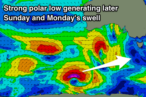
The surf is due to remain tiny into tomorrow and Sunday morning, but later in the day Sunday and Monday morning, we should see a good new long-period W/SW groundswell filling in.
The models aren't picking up this swell too well at all Sunday afternoon, but the strong polar low linked to the swell has already formed and is weakening south-southwest of WA, with the timing having it well and truly in by Sunday afternoon/evening.
A great fetch of severe-gale to storm-force W/SW tending W'ly winds will generate a good pulse of W/SW groundswell that should reach 2ft by dark, and easing from a similar size on Monday morning.
 Sea breezes will create bumpy conditions Sunday, with Monday morning the pick with a N/NW breeze, tending N/NE through the morning, freshening into the afternoon.
The swell should ease off through Tuesday from 1ft to possibly 2ft, though most likely 1-1.5ft with a N/NW tending NW and then W/NW breeze.
This will be associated with a weakening mid-latitude low moving across us, with no major swell due from it above 1-2ft at this stage.
We should see small levels of background W/SW groundswell to this size any way on Wednesday and Thursday, generated by a flurry of polar frontal activity south-west of WA, but strongest to the north and out of our swell window.
Longer term we may see some decent swell later next weekend onwards, but more on this Monday. Have a great weekend!

