Smaller swells with favourable winds until mid-next week
Southern Tasmania Surf Forecast by Craig Brokensha (issued Friday 5th October)
Best Days: Saturday, Sunday and Monday mornings
Recap
The large and powerful SW groundswell due yesterday came in as forecast with it overpowering Cifton but performing well in more protected spots. This morning the swell has eased off back from a still solid 3-4ft with cleaner conditions across Clifton but winds have since gone onshore from late morning.
Today’s Forecaster Notes are brought to you by Rip Curl
This weekend and next week (Oct 6 – 12)
The current swell should continue to ease back from 2-3ft tomorrow morning with a NW-W/NW offshore, giving into SE sea breezes into the afternoon.
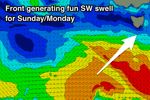
Sunday's new pulse of SW groundswell is still on track, with the polar frontal system linked to this currently south-west of us, with a poorly aimed pre-frontal fetch followed by a better post-frontal W/SW fetch.
 The post-frontal fetch of strong to sub-gale-force W/SW winds will generate the small spike in swell, with sets to 2ft+ due across Clifton, easing from 2ft on Monday morning.
A light morning offshore N/NW breeze is expected on Sunday morning, tending NE ahead of SE sea breezes, similar Monday but more N/NW tending SE.
Tuesday looks small but still 1-2ft, before a strong high and strengthening polar front push up and across us from the south, bringing a strong S/SW change and junky S'ly windswell for Wednesday as strong S'ly winds persist.
The windswell should ease through Thursday as winds slowly relax and we'll likely see smaller pulses of SW groundswell from polar fronts into next weekend, but we'll have another look at this Monday. Have a great weekend!

