Strong swells this period, large Thursday
Southern Tasmania Surf Forecast by Craig Brokensha (issued Monday 1st October)
Best Days: Every morning this week, Thursday all day
Recap
Fun small waves through the weekend, clean each morning ahead of a stronger swell into yesterday afternoon which has hung in this morning with solid though closey 3ft sets across Clifton.
Today’s Forecaster Notes are brought to you by Rip Curl
This week and weekend (Oct 2 - 7)
Today's strong pulse of W/SW groundswell should ease back through tomorrow, though still coming in at a good 2-3ft. Winds should be variable and light NW through the morning with winds tending more east and then SE into the afternoon.
Into Wednesday the first of a series of strong long-period SW groundswells should fill in, with a very large groundswell for Thursday.
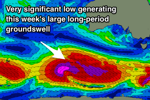
We've currently got a series of severe storms spread out along the polar shelf extending from the south-west of Tassie to the southern Indian Ocean.
The system linked to Wednesday's swell is producing a fetch of severe-gale W'ly winds on top an active sea state, with a long-period SW groundswell due to arrive overnight Tuesday and peak Wednesday morning to 3ft+ but an approaching surface trough will see early W/NW winds give into a SW change mid-morning.
 These winds look to mostly spoil our larger long-period SW groundswell event for Thursday across exposed breaks.
The groundswell is being generated by the strongest of the polar storms with a significant and broad pre-frontal fetch of severe-gale W/NW winds setting up an active sea state for post-frontal severe-gale to storm-force W/SW winds to move over, traversing east under the country and then under Tasmania.
We should see the swell starting to build later Wednesday ahead of a peak on Thursday morning to 5-6ft on the sets across Clifton but with winds from the SW. There's a high chance of an early light W/NW breeze but surfing options will be limited.
The swell should start easing Thursday afternoon, further through Friday but this easing trend will be slowed by a trailing fetch of strong to gale-force W'ly winds behind the severe storm.
Clifton should ease back from the 4ft range and conditions will be clean with a light NW offshore ahead of SE sea breezes.
A further drop should be seen Saturday with NW tending SE winds again.
A strong new SW groundswell is due Sunday from a strengthening polar low directly south-west of us late week, aiming a fetch of severe-gale to storm-force W/NW-W winds through our swell window.
A kick back to 3ft+ is due Sunday morning across Clifton with W/NW offshore winds, but we'll confirm this on Wednesday.

