Tons of swell this period, though dicey winds when it's largest
Southern Tasmania Surf Forecast by Craig Brokensha (issued Friday 28th September)
Best Days: Saturday, Sunday, Monday, Tuesday morning, Wednesday
Recap
Fun clean easing sets to 2ft yesterday morning, tiny into this morning though ideal for beginners.
Today’s Forecaster Notes are brought to you by Rip Curl
This weekend and next week (Sep 29 – Oct 5)
From tomorrow we've got a very active period ahead with strong back to back polar frontal systems moving through our swell window, becoming quite significant at stages.
Firstly tomorrow the weakest swell of the coming period is due, generated by a broad but relatively weak front moving in from the west the last couple of days.
Clifton should be a fun 2ft in the morning, with sets approaching 3ft into the afternoon as the best aligned component of the swell fills in.
Winds are now looking favourable most of the day with a NW tending W/NW breeze, keeping Clifton clean.
 From Sunday and more so Monday longer-period swell is energy is due to fill in, produced by back to back fetches of elongated W/NW gales.
The initial location of these W/NW gales will be further south and more in our swell window, arriving through Sunday afternoon and peaking Monday.
Size wise, Clifton should build 3ft+ later in the day and peak Monday at 3ft to occasionally 4ft.
Winds are looking great and offshore from the W/NW all day Sunday and then NW tending W/NW winds on Monday.
The swell should ease temporarily on Tuesday and a surface trough slipping across us may bring onshore SE winds, but it will mostly likely be variable through the morning.
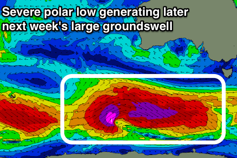
Of greater importance are back to back fetches of severe-gale W/NW winds sliding in from the south-east Indian Ocean along the polar shelf, with a final fetch of post-frontal severe-gale to storm-force W/SW winds around a very strong low due to generate a large long-period SW groundswell later in the week.
The initial W/NW fetch should produce a good SW groundswell for Wednesday to 3ft+ across Clifton with a light morning N'ly offshore ahead of sea breezes, while a larger SW groundswell due into Thursday up to 4-5ft+.
Unfortunately we're likely to see onshore S/SE winds as the swell peaks as another trough moves across and up the east coast of the state, but we'll confirm this on Monday. Have a great weekend!


Comments
FROTHING!!!!!!!!!!!!!!!!!!!!!!!!!
Apparently the Red Bull comp is moving to The Right next year.