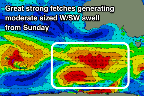
Lots of swell to come from the weekend, strong early next week
Southern Tasmania Surf Forecast by Craig Brokensha (issued Wednesday 26th September)
Best Days: Thursday, Saturday morning, Sunday, Monday, Tuesday
Recap
A building SW swell through yesterday with favourable winds in the morning, peaking this morning with a better aligned S/SW pulse though mixed conditions.
Today’s Forecaster Notes are brought to you by Rip Curl
This week and weekend (Sep 27 - 30)
Today's swell should be on the ease this afternoon and is expected to continue dropping from 2ft tomorrow morning with an early N/NE breeze that will improve and tend more NW into the afternoon.
Friday will be mostly tiny to flat, but our new W/SW swell for Saturday has been upgraded a touch.
The weak frontal system developing today and pushing west over the coming days looks a touch stronger along with a good kick in its tail, and with this we're expected to see a bit more size when it peaks on Saturday, most likely into the afternoon.
Clifton looks to offer 2ft waves through the morning with the odd 3ft'er likely into the afternoon under a W/NW tending W/SW breeze.
 Our stronger pulses of W/SW groundswell from Sunday through next week are still on track, with an elongated polar frontal progression firing up south-west of WA and pushing east all the way to our region.
An initial fetch of pre-frontal W/NW gales, reaching near severe-gale at times is expected to generate an initial strong W/SW groundswell for Sunday, building to an easy 3-4ft through the day.
A secondary fetch of less favourably aligned W/NW gales should generate a reinforcing W/SW swell for Monday to a similar size, easing back slowly through Tuesday and Wednesday.
Winds through this period will generally be out of the W/NW, with Monday seeing a better aligned NW offshore, variable into the afternoon and then possibly around to the NE Tuesday.
Longer term a very severe polar low is forecast to form south of WA early next week and project severe-gale to storm-force W/SW winds through our swell window, generating a large SW groundswell later in the week, but winds might be an issue. More on this Friday.

