Constant swell sources with windows of good winds
Southern Tasmania Surf Forecast by Craig Brokensha (issued Friday 21st September)
Best Days: Saturday morning, early Sunday, early Monday, early Tuesday, early Wednesday
Recap
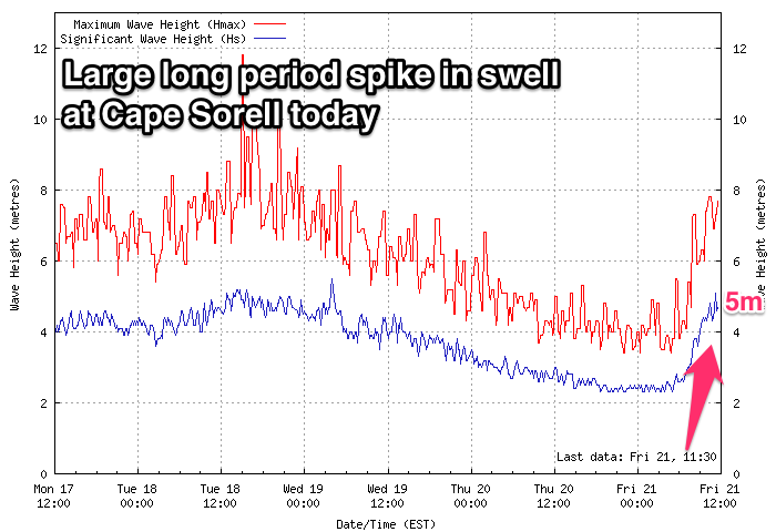
A small easing swell from 1-2ft yesterday morning, while this morning the beginnings of a new large long-period SW groundswell was coming in at 2ft.
This swell has sky-rocketed on the Cape Sorell buoy and will likely come in over Wednesday's forecast of 4ft, with larger sets due mid-late afternoon as winds hold out of the W/NW.
Today’s Forecaster Notes are brought to you by Rip Curl
This weekend and next week (Sep 22 - 28)

This afternoon's large and strong groundswell will peak overnight and ease back steadily through tomorrow, from 3ft early with a NW offshore, giving into a W/SW change early afternoon.
This change will be linked to a good polar frontal progression moving in from the west, though it won't be overly strong it will be double pronged.
Back to back fetches of strong to gale-force W/SW winds through our western swell window, will produce a moderate sized W/SW groundswell to 3ft+ Sunday, more so 3-4ft into the afternoon as the strongest part of the swell fills in.
Winds will unfortunately swing from a dawn W/NW breeze, strong SW mid-morning with the passing front, similar Monday morning and W/NW early as the swell eases from the 3ft range.
The larger S/SW groundswell possible for the middle of next week has been downgraded a touch with the bulk of the polar frontal activity occurring just a touch further east than ideal.
A strong node of the Long Wave Trough across New Zealand early next week will project a slow moving and strengthening polar fetch of W/SW tending SW gales through our southern swell window.
The swell should build through Tuesday with the most size seen Wednesday with what looks to be early W/NW winds.
Size wise we're looking at surf to 4ft or so on the sets, but we'll have a closer look at this Monday. Have a great weekend!

