Good active period with plenty of swell to come
Southern Tasmania Surf Forecast by Craig Brokensha (issued Friday 14th September)
Best Days: Saturday, brief window Sunday, Monday, later Tuesday, Wednesday morning
Recap
Tiny waves yesterday and this morning, but we may see a new W/SW groundswell kicking later today, though the weekend provides more potential for surf.
Today’s Forecaster Notes are brought to you by Rip Curl
This weekend and next week (Sep 15 - 21)
The W/SW groundswell due later today should peak tomorrow morning across Clifton, generated by a stalling fetch of gale to sub-gale-force W/SW winds south-southwest of WA earlier this week.
We should see good 3ft sets tomorrow morning, while there'll also be another close-range W/SW swell in the mix, generated by a south-east tracking and poorly aligned but very strong fetch of severe-gale to storm-force W/NW winds yesterday.
 Winds are looking funky now with a small embedded low moving in from the north-west bringing N'ly winds through the morning, swinging NW through the day and then W/NW ahead of a late strong SW change.
A small to moderate sized W/SW swell should fill in behind this change for Sunday morning but only to 2-3ft, ahead of a stronger groundswell signal arriving mid-late morning and peaking into the afternoon.
This swell was generated by a strong polar fetch of W/SW gales in a similar location to where tomorrow's swell was generated, though, the forward projection towards us may see sets pushing to 3ft+ as it fills in.
Winds now look suspect on Sunday owing to the late delayed onshore change Saturday evening, with only a short-lived W/NW breeze expected after all night onshores, likely resulting in lumpy raw conditions, swinging back onshore from the W/SW through the morning.
Later in the day though another approaching front may tip winds back W/NW so keep an eye on the local wind observations.
Monday will be much smaller with a mix of easing swells from 2ft+ though with a NW offshore.
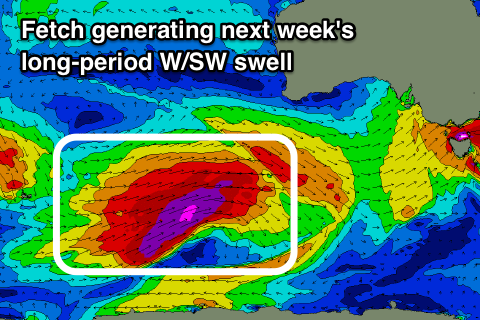
Into the middle of the week, a long-period and acute W'ly groundswell has been upgraded in size.
The storm linked to this swell has formed north of the Heard Island region, and it'll drift south-east and then east, projecting a fetch of severe-gale to storm-force W/SW winds through our far western swell window.
The storm will broaden while weakening and pushing closer towards us through Sunday afternoon and evening, dissolving while moving across us Monday evening.
We should see a moderate sized long-period W/SW groundswell arriving through Tuesday morning and building so a solid 3ft+ across Clifton by dark, easing from a similar size Wednesday morning.
Winds look great with a NW tending W/NW breeze on Tuesday and then an early W/NW breeze Wednesday morning ahead of a W/SW change, but more on this Monday. Have a great weekend!

