Strong swell late week and into the weekend
Southern Tasmania Surf Forecast by Craig Brokensha (issued Wednesday 11th July)
Best Days: Thursday morning, Saturday, Sunday morning
Recap
Fun clean easing surf from 2-3ft yesterday morning, though a touch bumpy at periods through the morning.
This morning a reinforcing swell has kept wave heights up around 2ft with clean conditions.
Today’s Forecaster Notes are brought to you by Rip Curl
This week and weekend (Jul 12 - 15)
Want to receive an email when these Forecaster Notes are updated? Then log in here and update your preferences.
There's no real change to the short-term forecast with a downwards trend in swell due tomorrow, easing from 1-2ft with a N/NW offshore, giving into SE winds into the afternoon.
 Friday morning will mark a low point in swell activity before our strong new SW groundswell kicks later in the day.
Morning W/NW winds will create clean conditions but when this swell arrives mid-late afternoon a W/SW change will create bumpy conditions.
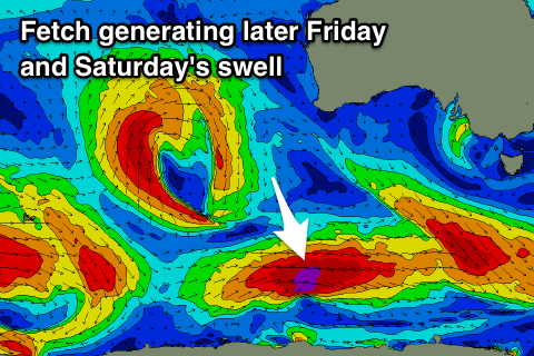
An intense polar low formed south-southwest of WA yesterday and we've already seen a great fetch of severe-gale to storm-force W'ly winds generated in our far swell window.
This low is moving slowly east while continuing to generate a fetch of gale to severe-gale W'ly winds and will weaken to our south-west tomorrow afternoon and evening.
We should see a strong long-period SW groundswell kicking late Friday and reaching 3ft by dark, with a peak early Saturday morning to 3ft to occasionally 4ft at Clifton, easing steadily through the day and back from a smaller 1-2ft Sunday morning.
Winds will vary but be good for various locations through the day with a morning N/NW breeze, tending NE into the afternoon, with N/NW tending SE winds on Sunday.
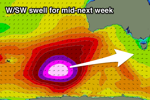
 Longer term the outlook will be quiet until a very significant polar frontal progression forming south-west of WA starts pushing slowly east through the weekend.
This progression will generate a significant fetch of severe-gale W'ly winds in our far swell window setting up an active sea state for polar storm-force W/SW winds to move over, producing an XXL groundswell for WA and SA.
This swell will come from a W/SW direction across our region through Wednesday and be moderate in size, but winds are the main issue, with the remnants of the storm looking to push across us in the form of a mid-latitude low, bringing onshore winds. More on this Friday though.

