Tiny weekend, lots of swell next week
Southern Tasmania Surf Forecast by Craig Brokensha (issued Friday 9th March)
Best Days: Beginners Saturday morning, Monday morning, Tuesday morning, Wednesday morning, Thursday morning
Recap
The new S/SW swell expected yesterday was a little slow at dawn but kicked in strongly through the morning. The swell has dropped back to the 2ft range this morning, helped by a reinforcing pulse.
Today’s Forecaster Notes are brought to you by Rip Curl
This week and weekend (Mar 10 - 16)
Today's swell should fade through the day, with tiny 1ft waves leftover tomorrow with an offshore wind, effectively flat Sunday as a strong front passes under us.
Our active week of swell is still on the cards as a strengthening node of the Long Wave Trough moves very slowly across us.
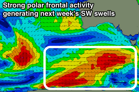
 This will direct a series of vigorous polar fronts up through our swell window, the first forming tomorrow afternoon south of WA.
A fetch of gale to severe-gale W/SW winds will be projected through our swell window, with a moderate sized SW groundswell due to build through Monday, reaching 3-4ft into the afternoon across Clifton.
A secondary more polar fetch of severe-gale W/SW winds will produce a similar sized reinforcing pulse for Tuesday morning.
We'll see the swell start easing Tuesday afternoon, but another weaker but broad fetch of W'ly gales moving in early next week should generate a reinforcing W/SW swell Wednesday keeping 3ft sets hitting the region through the morning.
Winds through this period will be favourable each morning and from the W/NW (NW Wednesday morning) before shifting more onshore through each day.
Later in the week we're likely to see a final polar front push up and into us, generating a stormy increase in S/SW swell, but more on this Monday. Have a great weekend!

