Building swell through the week, biggest later Friday/Saturday
Southern Tasmania Surf Forecast by Craig Brokensha (issued Monday 12th February)
Best Days: Beginners Tuesday and Wednesday mornings, Thursday morning, early Friday morning, Saturday
Recap
Tiny leftover sets out of the S/SE on Saturday morning, with onshore winds and tiny waves yesterday.
This morning the surf remained minimal across the South Arm.
Today’s Forecaster Notes are brought to you by Rip Curl
This week and weekend (Feb 13 - 18)
As touched on in Friday's update, swells due tomorrow and Wednesday will be mainly too west to generate any decent size owing to the fronts generating them being positioned too far north.
It won't be flat though with Clifton expected to see 1-1.5ft sets with a morning NW offshore ahead of sea breezes tomorrow and gusty N/NE tending strong W'ly winds Wednesday.
This strong change will be linked to a couple of better aligned mid-latitude fronts pushing in from the west, bringing back to back fetches of strong to gale-force W/SW winds through our western swell window.
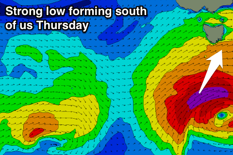
 We'll then see a strong polar low developing south of us, stalling and aiming severe-gale to nearly storm-force W/SW winds in our southern swell window, generating some better S/SW groundswell later Friday and Saturday morning.
Size wise we could see a late increase in W/SW swell Wednesday but more so Thursday to 2ft+ across Clifton during the morning, building further later and coming in more around 2-3ft Friday morning.
The S/SW swell should build later Friday to 3-4ft, easing from 3ft Saturday morning.
Winds through this period will be best early each morning and out of the W/NW with Saturday seeing NW tending W/NW breezes.
We may see an onshore change Sunday with a small increase in new swell, but we'll review this Wednesday.

