Fading surf, new swell from later Sunday
Southern Tasmania Surf Forecast by Craig Brokensha (issued Monday 15th January)
Best Days: Thursday morning, Monday morning, Tuesday/Wednesday
Recap
Plenty of S/SW swell yesterday but with onshore winds, while this morning we've got a stronger W/SW groundswell with early clean conditions which have now given into sea breezes.
Today’s Forecaster Notes are brought to you by Rip Curl
This week and weekend (Jan 18 - 21)
Today's long-period and strong W/SW groundswell is expected to ease back through tomorrow from a smaller 2ft on the sets with a light N/NW offshore ahead of SE sea breezes.
 The swell will then become tiny into Friday and the weekend, with the next increase in swell due to be seen later Sunday but more so Monday and then possibly Tuesday/Wednesday.
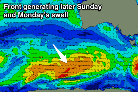
Later Sunday and more so Monday's SW groundswell will be generated by a persistent and elongated polar frontal progression moving along the polar shelf over the coming days before breaking down under us Saturday.
A fetch of strong to gale-force W/SW winds should produce an initial increase in size later Sunday to 2ft across Clifton but with SE sea breezes, coming in at a stronger 2ft+ Monday morning with a NW tending W/SW breeze.
We may see a secondary mid-latitude front developing west of us on Sunday and Monday, generating a great fetch of gale to severe-gale W/SW winds in our swell window. This would generate a solid spike in W/SW swell for later Tuesday and Wednesday, but we'll look at this closer on Friday.

