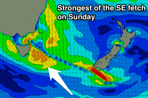
SE windswell developing over the weekend
Southern Tasmania Surf Forecast by Craig Brokensha (issued Wednesday 29th November)
Best Days: Protected spots Sunday/Monday
Recap
Poor conditions with an increase in swell yesterday, fading from 1-1.5ft this morning with decent winds for more exposed breaks.
Today’s Forecaster Notes are brought to you by Rip Curl
This week and weekend (Nov 30 – Dec 3)
As touched on last update, there's no significant groundswell on the cards for the coming days, but we're now due to see some bigger S/SE windswell across the region over the weekend.
This will be a result of a deepening surface trough and eventual low forming to our east over the weekend, with a strengthening fetch of S/SE winds developing in our swell window Friday evening and Saturday, becoming even more intense through Sunday before weakening Monday.
 This will result in building levels of S/SE windswell over the weekend, strongest Sunday afternoon and Monday morning out of the SE and then easing.
Clifton is likely to see building surf to 3ft+ Saturday afternoon, further towards 4ft later Sunday, easing back from a similar size Monday morning. Exposed spots to the SE swell will be bigger again.
Unfortunately winds through this period will be onshore and from the SE, tending more S'ly Monday and still lingering into Tuesday.
This will limit surfing options but savvy operators should be able to find some decent surf.
Beyond this there's nothing significant on the cards for the rest of next week.

